You are here: Home > Network List > TA - USArray Transportable Network (new EarthScope stations) Stations List
> Station H17A Grant Village (NPS), Yellowstone Nt. Park, WY, USA > Earthquake Result Viewer
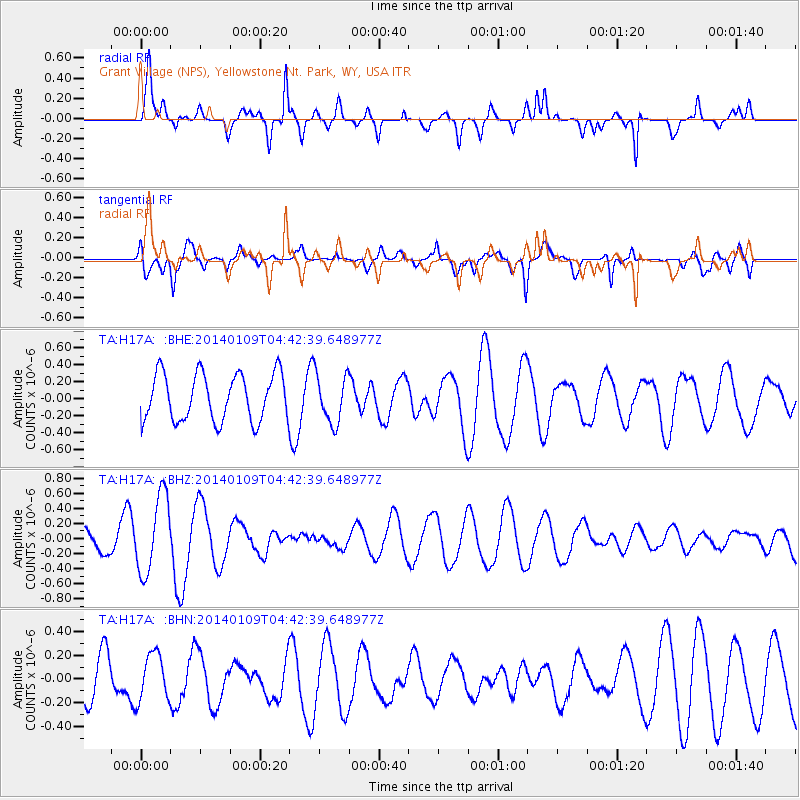
H17A Grant Village (NPS), Yellowstone Nt. Park, WY, USA - Earthquake Result Viewer
*The percent match for this event was below the threshold and hence no stack was calculated.
| Earthquake location: |
Hokkaido, Japan Region |
| Earthquake latitude/longitude: |
42.1/142.7 |
| Earthquake time(UTC): |
2014/01/09 (009) 04:31:54 GMT |
| Earthquake Depth: |
64 km |
| Earthquake Magnitude: |
4.8 MW |
| Earthquake Catalog/Contributor: |
ISC/ISC |
|
| Network: |
TA USArray Transportable Network (new EarthScope stations) |
| Station: |
H17A Grant Village (NPS), Yellowstone Nt. Park, WY, USA |
| Lat/Lon: |
44.40 N/110.58 W |
| Elevation: |
2400 m |
|
| Distance: |
71.8 deg |
| Az: |
46.253 deg |
| Baz: |
311.399 deg |
| Ray Param: |
$rayparam |
*The percent match for this event was below the threshold and hence was not used in the summary stack. |
|
| Radial Match: |
59.12882 % |
| Radial Bump: |
400 |
| Transverse Match: |
50.08702 % |
| Transverse Bump: |
400 |
| SOD ConfigId: |
3390531 |
| Insert Time: |
2019-04-09 22:49:54.583 +0000 |
| GWidth: |
2.5 |
| Max Bumps: |
400 |
| Tol: |
0.001 |
|
Signal To Noise
| Channel | StoN | STA | LTA |
| TA:H17A: :BHZ:20140109T04:42:39.648977Z | 2.8024964 | 5.126216E-7 | 1.8291605E-7 |
| TA:H17A: :BHN:20140109T04:42:39.648977Z | 0.7718183 | 1.9514684E-7 | 2.528404E-7 |
| TA:H17A: :BHE:20140109T04:42:39.648977Z | 1.0353767 | 2.8470865E-7 | 2.7498072E-7 |
| Arrivals |
| Ps | |
| PpPs | |
| PsPs/PpSs | |


