You are here: Home > Network List > IW - Intermountain West Stations List
> Station DLMT Dillon, Montana, USA > Earthquake Result Viewer
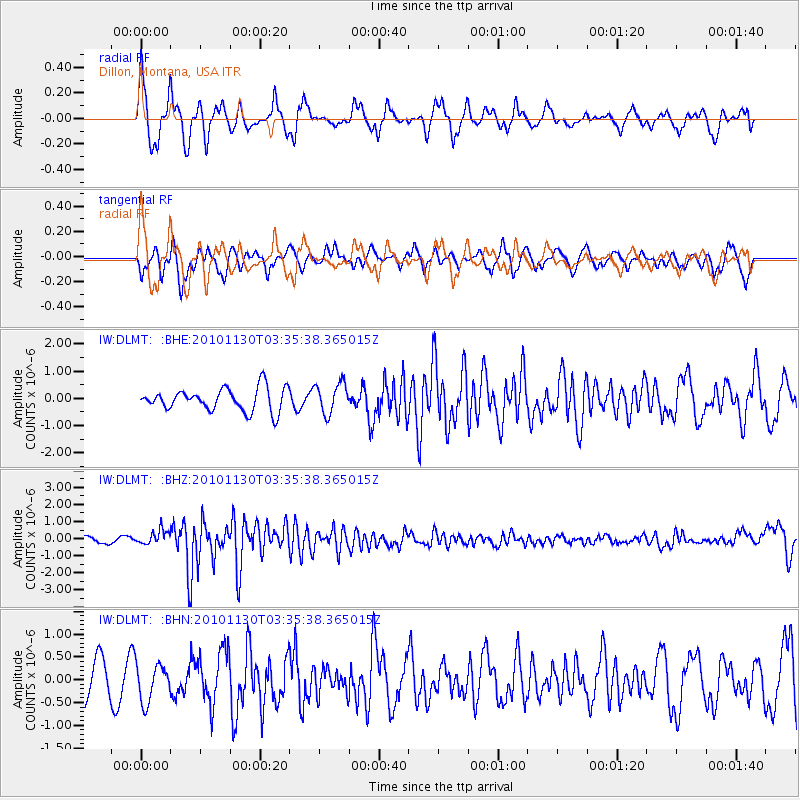
DLMT Dillon, Montana, USA - Earthquake Result Viewer
*The percent match for this event was below the threshold and hence no stack was calculated.
| Earthquake location: |
Bonin Islands, Japan Region |
| Earthquake latitude/longitude: |
28.4/139.2 |
| Earthquake time(UTC): |
2010/11/30 (334) 03:24:41 GMT |
| Earthquake Depth: |
487 km |
| Earthquake Magnitude: |
5.9 MB, 6.8 MW, 6.8 MW |
| Earthquake Catalog/Contributor: |
WHDF/NEIC |
|
| Network: |
IW Intermountain West |
| Station: |
DLMT Dillon, Montana, USA |
| Lat/Lon: |
45.36 N/112.60 W |
| Elevation: |
1569 m |
|
| Distance: |
81.9 deg |
| Az: |
42.552 deg |
| Baz: |
302.288 deg |
| Ray Param: |
$rayparam |
*The percent match for this event was below the threshold and hence was not used in the summary stack. |
|
| Radial Match: |
68.84484 % |
| Radial Bump: |
400 |
| Transverse Match: |
57.24295 % |
| Transverse Bump: |
292 |
| SOD ConfigId: |
343951 |
| Insert Time: |
2011-05-23 23:52:44.850 +0000 |
| GWidth: |
2.5 |
| Max Bumps: |
400 |
| Tol: |
0.001 |
|
Signal To Noise
| Channel | StoN | STA | LTA |
| IW:DLMT: :BHZ:20101130T03:35:38.365015Z | 2.111149 | 4.2167687E-7 | 1.9973807E-7 |
| IW:DLMT: :BHN:20101130T03:35:38.365015Z | 1.078982 | 4.0393155E-7 | 3.743636E-7 |
| IW:DLMT: :BHE:20101130T03:35:38.365015Z | 1.350294 | 5.606795E-7 | 4.152277E-7 |
| Arrivals |
| Ps | |
| PpPs | |
| PsPs/PpSs | |


