You are here: Home > Network List > TA - USArray Transportable Network (new EarthScope stations) Stations List
> Station L02D Cave Junction, OR, USA > Earthquake Result Viewer
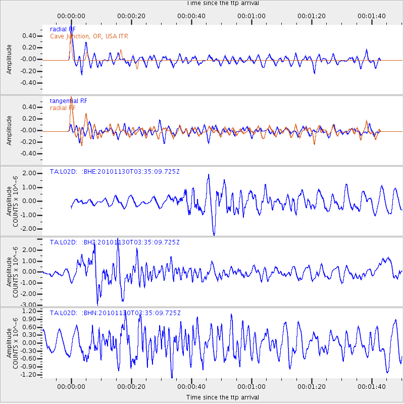
L02D Cave Junction, OR, USA - Earthquake Result Viewer
*The percent match for this event was below the threshold and hence no stack was calculated.
| Earthquake location: |
Bonin Islands, Japan Region |
| Earthquake latitude/longitude: |
28.4/139.2 |
| Earthquake time(UTC): |
2010/11/30 (334) 03:24:41 GMT |
| Earthquake Depth: |
487 km |
| Earthquake Magnitude: |
5.9 MB, 6.8 MW, 6.8 MW |
| Earthquake Catalog/Contributor: |
WHDF/NEIC |
|
| Network: |
TA USArray Transportable Network (new EarthScope stations) |
| Station: |
L02D Cave Junction, OR, USA |
| Lat/Lon: |
42.16 N/123.60 W |
| Elevation: |
458 m |
|
| Distance: |
76.5 deg |
| Az: |
49.336 deg |
| Baz: |
295.96 deg |
| Ray Param: |
$rayparam |
*The percent match for this event was below the threshold and hence was not used in the summary stack. |
|
| Radial Match: |
72.89396 % |
| Radial Bump: |
400 |
| Transverse Match: |
64.38931 % |
| Transverse Bump: |
400 |
| SOD ConfigId: |
343951 |
| Insert Time: |
2011-05-24 00:28:40.011 +0000 |
| GWidth: |
2.5 |
| Max Bumps: |
400 |
| Tol: |
0.001 |
|
Signal To Noise
| Channel | StoN | STA | LTA |
| TA:L02D: :BHZ:20101130T03:35:09.725Z | 3.0665495 | 8.0727E-7 | 2.6325029E-7 |
| TA:L02D: :BHN:20101130T03:35:09.725Z | 1.7075443 | 4.2175725E-7 | 2.4699636E-7 |
| TA:L02D: :BHE:20101130T03:35:09.725Z | 1.4436973 | 3.0599398E-7 | 2.1195162E-7 |
| Arrivals |
| Ps | |
| PpPs | |
| PsPs/PpSs | |


