You are here: Home > Network List > TA - USArray Transportable Network (new EarthScope stations) Stations List
> Station F31A Hecla, SD, USA > Earthquake Result Viewer
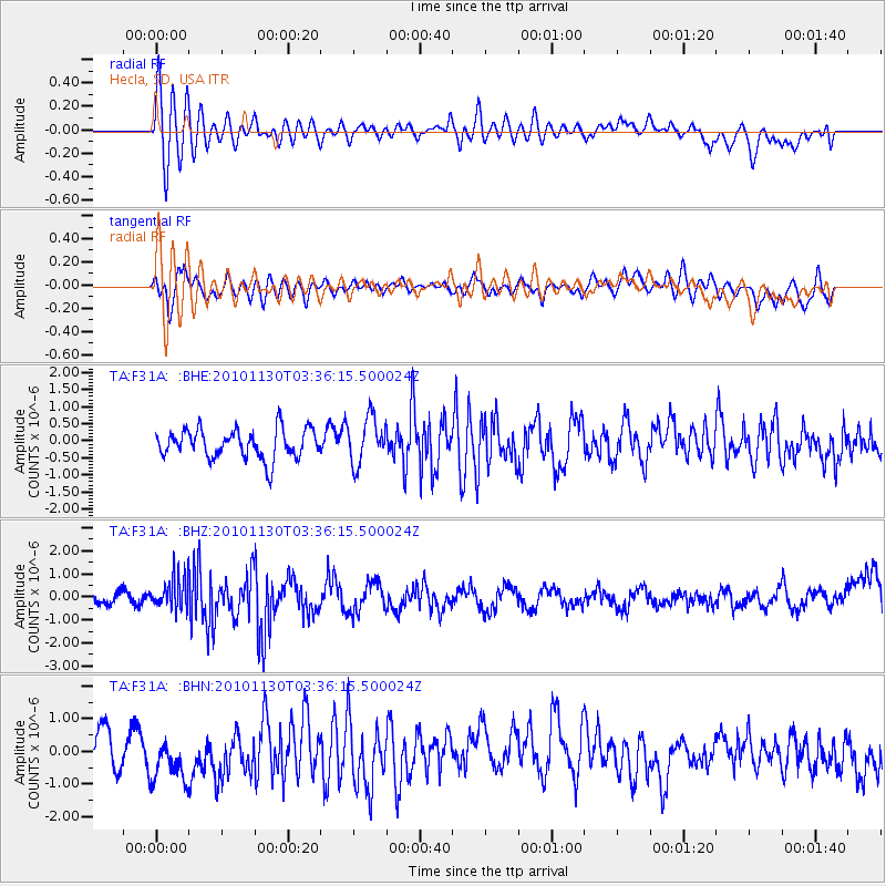
F31A Hecla, SD, USA - Earthquake Result Viewer
*The percent match for this event was below the threshold and hence no stack was calculated.
| Earthquake location: |
Bonin Islands, Japan Region |
| Earthquake latitude/longitude: |
28.4/139.2 |
| Earthquake time(UTC): |
2010/11/30 (334) 03:24:41 GMT |
| Earthquake Depth: |
487 km |
| Earthquake Magnitude: |
5.9 MB, 6.8 MW, 6.8 MW |
| Earthquake Catalog/Contributor: |
WHDF/NEIC |
|
| Network: |
TA USArray Transportable Network (new EarthScope stations) |
| Station: |
F31A Hecla, SD, USA |
| Lat/Lon: |
45.86 N/98.25 W |
| Elevation: |
412 m |
|
| Distance: |
89.6 deg |
| Az: |
36.07 deg |
| Baz: |
312.053 deg |
| Ray Param: |
$rayparam |
*The percent match for this event was below the threshold and hence was not used in the summary stack. |
|
| Radial Match: |
66.13685 % |
| Radial Bump: |
399 |
| Transverse Match: |
64.17957 % |
| Transverse Bump: |
397 |
| SOD ConfigId: |
343951 |
| Insert Time: |
2011-05-24 00:38:17.065 +0000 |
| GWidth: |
2.5 |
| Max Bumps: |
400 |
| Tol: |
0.001 |
|
Signal To Noise
| Channel | StoN | STA | LTA |
| TA:F31A: :BHZ:20101130T03:36:15.500024Z | 2.1602833 | 6.877771E-7 | 3.1837357E-7 |
| TA:F31A: :BHN:20101130T03:36:15.500024Z | 1.1045899 | 7.1418714E-7 | 6.4656314E-7 |
| TA:F31A: :BHE:20101130T03:36:15.500024Z | 1.5871392 | 6.750808E-7 | 4.253444E-7 |
| Arrivals |
| Ps | |
| PpPs | |
| PsPs/PpSs | |


