You are here: Home > Network List > TA - USArray Transportable Network (new EarthScope stations) Stations List
> Station B34A Aery, Baudette, MN, USA > Earthquake Result Viewer
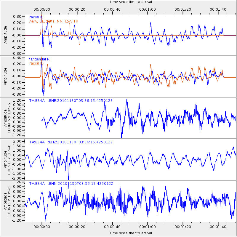
B34A Aery, Baudette, MN, USA - Earthquake Result Viewer
*The percent match for this event was below the threshold and hence no stack was calculated.
| Earthquake location: |
Bonin Islands, Japan Region |
| Earthquake latitude/longitude: |
28.4/139.2 |
| Earthquake time(UTC): |
2010/11/30 (334) 03:24:41 GMT |
| Earthquake Depth: |
487 km |
| Earthquake Magnitude: |
5.9 MB, 6.8 MW, 6.8 MW |
| Earthquake Catalog/Contributor: |
WHDF/NEIC |
|
| Network: |
TA USArray Transportable Network (new EarthScope stations) |
| Station: |
B34A Aery, Baudette, MN, USA |
| Lat/Lon: |
48.49 N/94.65 W |
| Elevation: |
354 m |
|
| Distance: |
89.6 deg |
| Az: |
32.473 deg |
| Baz: |
314.665 deg |
| Ray Param: |
$rayparam |
*The percent match for this event was below the threshold and hence was not used in the summary stack. |
|
| Radial Match: |
47.383327 % |
| Radial Bump: |
400 |
| Transverse Match: |
58.1975 % |
| Transverse Bump: |
400 |
| SOD ConfigId: |
343951 |
| Insert Time: |
2011-05-24 00:38:38.711 +0000 |
| GWidth: |
2.5 |
| Max Bumps: |
400 |
| Tol: |
0.001 |
|
Signal To Noise
| Channel | StoN | STA | LTA |
| TA:B34A: :BHZ:20101130T03:36:15.425012Z | 2.2173061 | 6.927591E-7 | 3.1243277E-7 |
| TA:B34A: :BHN:20101130T03:36:15.425012Z | 2.0594926 | 5.40797E-7 | 2.625875E-7 |
| TA:B34A: :BHE:20101130T03:36:15.425012Z | 1.6504132 | 4.3946244E-7 | 2.6627418E-7 |
| Arrivals |
| Ps | |
| PpPs | |
| PsPs/PpSs | |


