You are here: Home > Network List > US - United States National Seismic Network Stations List
> Station AMTX Amarillo, Texas, USA > Earthquake Result Viewer
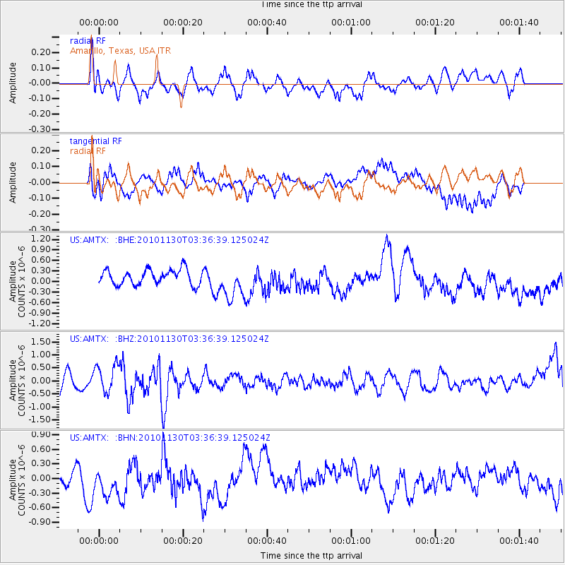
AMTX Amarillo, Texas, USA - Earthquake Result Viewer
*The percent match for this event was below the threshold and hence no stack was calculated.
| Earthquake location: |
Bonin Islands, Japan Region |
| Earthquake latitude/longitude: |
28.4/139.2 |
| Earthquake time(UTC): |
2010/11/30 (334) 03:24:41 GMT |
| Earthquake Depth: |
487 km |
| Earthquake Magnitude: |
5.9 MB, 6.8 MW, 6.8 MW |
| Earthquake Catalog/Contributor: |
WHDF/NEIC |
|
| Network: |
US United States National Seismic Network |
| Station: |
AMTX Amarillo, Texas, USA |
| Lat/Lon: |
34.53 N/101.41 W |
| Elevation: |
1010 m |
|
| Distance: |
95.2 deg |
| Az: |
46.22 deg |
| Baz: |
309.581 deg |
| Ray Param: |
$rayparam |
*The percent match for this event was below the threshold and hence was not used in the summary stack. |
|
| Radial Match: |
49.579777 % |
| Radial Bump: |
400 |
| Transverse Match: |
49.66439 % |
| Transverse Bump: |
340 |
| SOD ConfigId: |
343951 |
| Insert Time: |
2011-05-24 00:46:10.880 +0000 |
| GWidth: |
2.5 |
| Max Bumps: |
400 |
| Tol: |
0.001 |
|
Signal To Noise
| Channel | StoN | STA | LTA |
| US:AMTX: :BHZ:20101130T03:36:39.125024Z | 2.3121178 | 5.44804E-7 | 2.3562986E-7 |
| US:AMTX: :BHN:20101130T03:36:39.125024Z | 1.5253177 | 3.294855E-7 | 2.1601107E-7 |
| US:AMTX: :BHE:20101130T03:36:39.125024Z | 2.6003013 | 5.633276E-7 | 2.1663936E-7 |
| Arrivals |
| Ps | |
| PpPs | |
| PsPs/PpSs | |


