You are here: Home > Network List > US - United States National Seismic Network Stations List
> Station EGMT Eagleton, Montana, USA > Earthquake Result Viewer
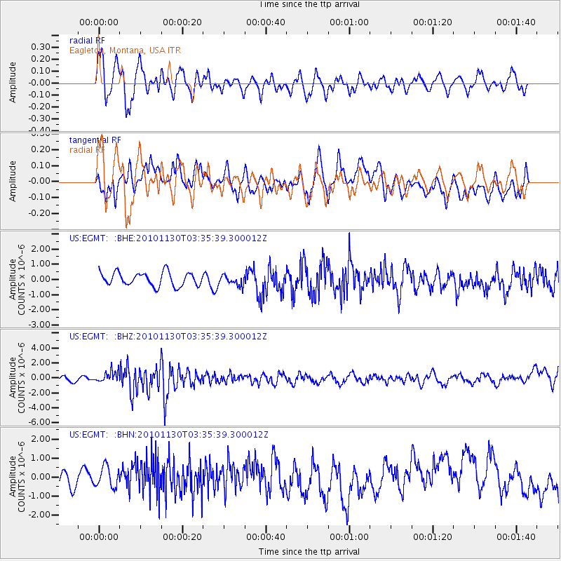
EGMT Eagleton, Montana, USA - Earthquake Result Viewer
*The percent match for this event was below the threshold and hence no stack was calculated.
| Earthquake location: |
Bonin Islands, Japan Region |
| Earthquake latitude/longitude: |
28.4/139.2 |
| Earthquake time(UTC): |
2010/11/30 (334) 03:24:41 GMT |
| Earthquake Depth: |
487 km |
| Earthquake Magnitude: |
5.9 MB, 6.8 MW, 6.8 MW |
| Earthquake Catalog/Contributor: |
WHDF/NEIC |
|
| Network: |
US United States National Seismic Network |
| Station: |
EGMT Eagleton, Montana, USA |
| Lat/Lon: |
48.02 N/109.75 W |
| Elevation: |
1055 m |
|
| Distance: |
82.1 deg |
| Az: |
39.221 deg |
| Baz: |
303.887 deg |
| Ray Param: |
$rayparam |
*The percent match for this event was below the threshold and hence was not used in the summary stack. |
|
| Radial Match: |
63.387062 % |
| Radial Bump: |
400 |
| Transverse Match: |
41.67973 % |
| Transverse Bump: |
400 |
| SOD ConfigId: |
343951 |
| Insert Time: |
2011-05-24 00:47:03.715 +0000 |
| GWidth: |
2.5 |
| Max Bumps: |
400 |
| Tol: |
0.001 |
|
Signal To Noise
| Channel | StoN | STA | LTA |
| US:EGMT: :BHZ:20101130T03:35:39.300012Z | 2.7477345 | 7.7818606E-7 | 2.8321006E-7 |
| US:EGMT: :BHN:20101130T03:35:39.300012Z | 1.0743016 | 5.5130647E-7 | 5.131766E-7 |
| US:EGMT: :BHE:20101130T03:35:39.300012Z | 0.74139506 | 3.290731E-7 | 4.438566E-7 |
| Arrivals |
| Ps | |
| PpPs | |
| PsPs/PpSs | |


