You are here: Home > Network List > UW - Pacific Northwest Regional Seismic Network Stations List
> Station YACT Amboy, WA, USA > Earthquake Result Viewer
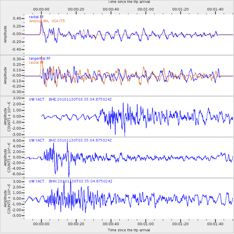
YACT Amboy, WA, USA - Earthquake Result Viewer
*The percent match for this event was below the threshold and hence no stack was calculated.
| Earthquake location: |
Bonin Islands, Japan Region |
| Earthquake latitude/longitude: |
28.4/139.2 |
| Earthquake time(UTC): |
2010/11/30 (334) 03:24:41 GMT |
| Earthquake Depth: |
487 km |
| Earthquake Magnitude: |
5.9 MB, 6.8 MW, 6.8 MW |
| Earthquake Catalog/Contributor: |
WHDF/NEIC |
|
| Network: |
UW Pacific Northwest Regional Seismic Network |
| Station: |
YACT Amboy, WA, USA |
| Lat/Lon: |
45.93 N/122.42 W |
| Elevation: |
211 m |
|
| Distance: |
75.6 deg |
| Az: |
45.455 deg |
| Baz: |
295.845 deg |
| Ray Param: |
$rayparam |
*The percent match for this event was below the threshold and hence was not used in the summary stack. |
|
| Radial Match: |
74.98879 % |
| Radial Bump: |
400 |
| Transverse Match: |
66.64834 % |
| Transverse Bump: |
400 |
| SOD ConfigId: |
343951 |
| Insert Time: |
2011-05-24 00:48:47.673 +0000 |
| GWidth: |
2.5 |
| Max Bumps: |
400 |
| Tol: |
0.001 |
|
Signal To Noise
| Channel | StoN | STA | LTA |
| UW:YACT: :BHZ:20101130T03:35:04.875024Z | 5.051942 | 1.1362856E-6 | 2.2492056E-7 |
| UW:YACT: :BHN:20101130T03:35:04.875024Z | 1.2273184 | 4.736609E-7 | 3.8593154E-7 |
| UW:YACT: :BHE:20101130T03:35:04.875024Z | 1.6627954 | 4.3456558E-7 | 2.6134637E-7 |
| Arrivals |
| Ps | |
| PpPs | |
| PsPs/PpSs | |


