You are here: Home > Network List > UW - Pacific Northwest Regional Seismic Network Stations List
> Station LEBA Lebam, WA, USA > Earthquake Result Viewer
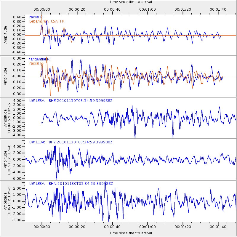
LEBA Lebam, WA, USA - Earthquake Result Viewer
*The percent match for this event was below the threshold and hence no stack was calculated.
| Earthquake location: |
Bonin Islands, Japan Region |
| Earthquake latitude/longitude: |
28.4/139.2 |
| Earthquake time(UTC): |
2010/11/30 (334) 03:24:41 GMT |
| Earthquake Depth: |
487 km |
| Earthquake Magnitude: |
5.9 MB, 6.8 MW, 6.8 MW |
| Earthquake Catalog/Contributor: |
WHDF/NEIC |
|
| Network: |
UW Pacific Northwest Regional Seismic Network |
| Station: |
LEBA Lebam, WA, USA |
| Lat/Lon: |
46.55 N/123.56 W |
| Elevation: |
73 m |
|
| Distance: |
74.6 deg |
| Az: |
45.234 deg |
| Baz: |
294.965 deg |
| Ray Param: |
$rayparam |
*The percent match for this event was below the threshold and hence was not used in the summary stack. |
|
| Radial Match: |
56.159557 % |
| Radial Bump: |
400 |
| Transverse Match: |
60.471542 % |
| Transverse Bump: |
400 |
| SOD ConfigId: |
343951 |
| Insert Time: |
2011-05-24 00:50:02.110 +0000 |
| GWidth: |
2.5 |
| Max Bumps: |
400 |
| Tol: |
0.001 |
|
Signal To Noise
| Channel | StoN | STA | LTA |
| UW:LEBA: :BHZ:20101130T03:34:59.399988Z | 2.2112157 | 1.1397678E-6 | 5.154485E-7 |
| UW:LEBA: :BHN:20101130T03:34:59.399988Z | 0.96101093 | 6.277128E-7 | 6.5317965E-7 |
| UW:LEBA: :BHE:20101130T03:34:59.399988Z | 1.8426267 | 1.1293982E-6 | 6.129284E-7 |
| Arrivals |
| Ps | |
| PpPs | |
| PsPs/PpSs | |


