You are here: Home > Network List > IC - New China Digital Seismograph Network Stations List
> Station ENH Enshi, Hubei Province, China > Earthquake Result Viewer
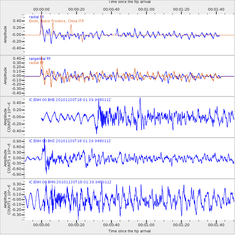
ENH Enshi, Hubei Province, China - Earthquake Result Viewer
*The percent match for this event was below the threshold and hence no stack was calculated.
| Earthquake location: |
Kuril Islands |
| Earthquake latitude/longitude: |
48.9/154.9 |
| Earthquake time(UTC): |
2010/11/30 (334) 17:54:47 GMT |
| Earthquake Depth: |
35 km |
| Earthquake Magnitude: |
5.7 MW, 5.2 MS, 5.4 MB, 5.6 MW |
| Earthquake Catalog/Contributor: |
WHDF/NEIC |
|
| Network: |
IC New China Digital Seismograph Network |
| Station: |
ENH Enshi, Hubei Province, China |
| Lat/Lon: |
30.28 N/109.49 E |
| Elevation: |
500 m |
|
| Distance: |
39.0 deg |
| Az: |
258.49 deg |
| Baz: |
48.343 deg |
| Ray Param: |
$rayparam |
*The percent match for this event was below the threshold and hence was not used in the summary stack. |
|
| Radial Match: |
72.66102 % |
| Radial Bump: |
400 |
| Transverse Match: |
56.85956 % |
| Transverse Bump: |
400 |
| SOD ConfigId: |
343951 |
| Insert Time: |
2011-05-24 01:28:49.633 +0000 |
| GWidth: |
2.5 |
| Max Bumps: |
400 |
| Tol: |
0.001 |
|
Signal To Noise
| Channel | StoN | STA | LTA |
| IC:ENH:00:BHZ:20101130T18:01:39.948011Z | 5.086202 | 4.0398055E-7 | 7.9426755E-8 |
| IC:ENH:00:BHN:20101130T18:01:39.948011Z | 1.9042753 | 1.4727802E-7 | 7.7340715E-8 |
| IC:ENH:00:BHE:20101130T18:01:39.948011Z | 2.7499588 | 2.1256383E-7 | 7.7297095E-8 |
| Arrivals |
| Ps | |
| PpPs | |
| PsPs/PpSs | |


