You are here: Home > Network List > KN - Kyrgyz Seismic Telemetry Network Stations List
> Station KZA KN.KZA > Earthquake Result Viewer
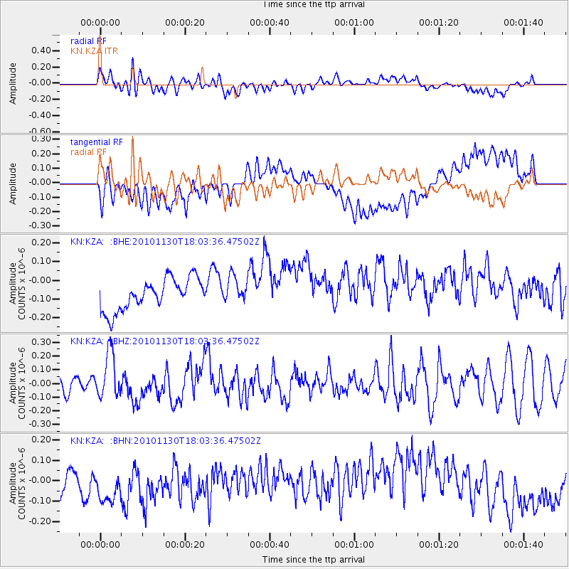
KZA KN.KZA - Earthquake Result Viewer
*The percent match for this event was below the threshold and hence no stack was calculated.
| Earthquake location: |
Kuril Islands |
| Earthquake latitude/longitude: |
48.9/154.9 |
| Earthquake time(UTC): |
2010/11/30 (334) 17:54:47 GMT |
| Earthquake Depth: |
35 km |
| Earthquake Magnitude: |
5.7 MW, 5.2 MS, 5.4 MB, 5.6 MW |
| Earthquake Catalog/Contributor: |
WHDF/NEIC |
|
| Network: |
KN Kyrgyz Seismic Telemetry Network |
| Station: |
KZA KN.KZA |
| Lat/Lon: |
42.08 N/75.25 E |
| Elevation: |
3520 m |
|
| Distance: |
53.9 deg |
| Az: |
294.904 deg |
| Baz: |
53.476 deg |
| Ray Param: |
$rayparam |
*The percent match for this event was below the threshold and hence was not used in the summary stack. |
|
| Radial Match: |
52.493122 % |
| Radial Bump: |
400 |
| Transverse Match: |
42.841625 % |
| Transverse Bump: |
400 |
| SOD ConfigId: |
343951 |
| Insert Time: |
2011-05-24 01:34:39.563 +0000 |
| GWidth: |
2.5 |
| Max Bumps: |
400 |
| Tol: |
0.001 |
|
Signal To Noise
| Channel | StoN | STA | LTA |
| KN:KZA: :BHZ:20101130T18:03:36.47502Z | 3.263218 | 1.7180096E-7 | 5.264771E-8 |
| KN:KZA: :BHN:20101130T18:03:36.47502Z | 1.932832 | 1.7527927E-7 | 9.0685205E-8 |
| KN:KZA: :BHE:20101130T18:03:36.47502Z | 0.88568926 | 7.3125314E-8 | 8.256317E-8 |
| Arrivals |
| Ps | |
| PpPs | |
| PsPs/PpSs | |


