You are here: Home > Network List > TA - USArray Transportable Network (new EarthScope stations) Stations List
> Station D30A Buchanan, ND, USA > Earthquake Result Viewer
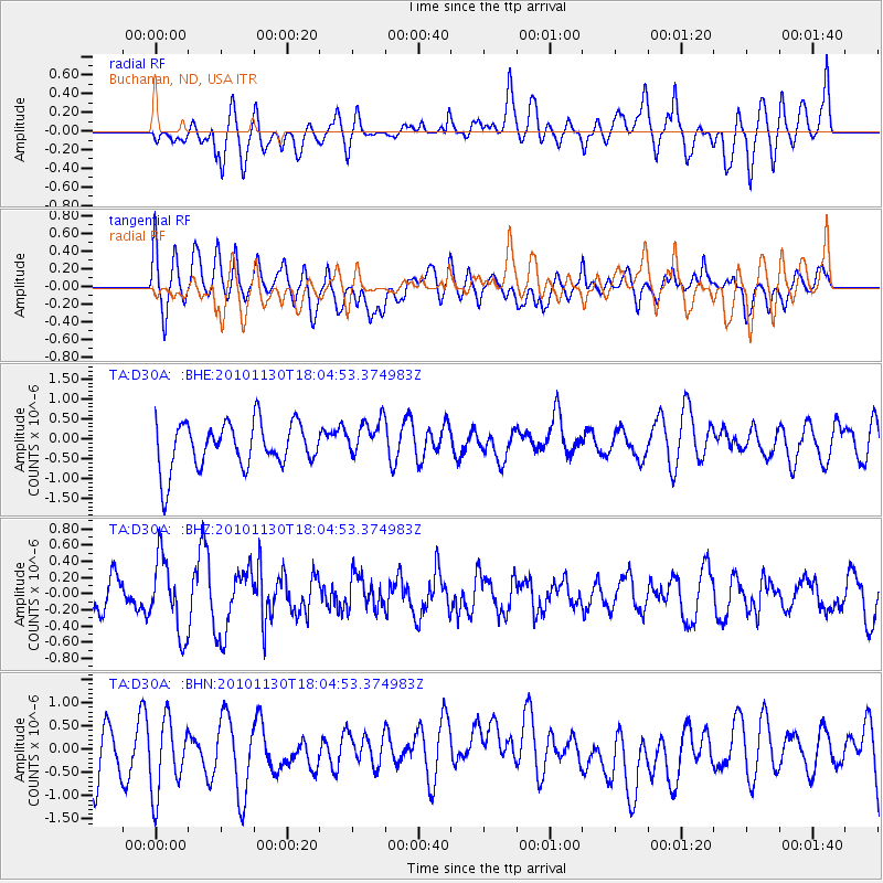
D30A Buchanan, ND, USA - Earthquake Result Viewer
*The percent match for this event was below the threshold and hence no stack was calculated.
| Earthquake location: |
Kuril Islands |
| Earthquake latitude/longitude: |
48.9/154.9 |
| Earthquake time(UTC): |
2010/11/30 (334) 17:54:47 GMT |
| Earthquake Depth: |
35 km |
| Earthquake Magnitude: |
5.7 MW, 5.2 MS, 5.4 MB, 5.6 MW |
| Earthquake Catalog/Contributor: |
WHDF/NEIC |
|
| Network: |
TA USArray Transportable Network (new EarthScope stations) |
| Station: |
D30A Buchanan, ND, USA |
| Lat/Lon: |
47.11 N/98.76 W |
| Elevation: |
465 m |
|
| Distance: |
65.0 deg |
| Az: |
46.318 deg |
| Baz: |
315.707 deg |
| Ray Param: |
$rayparam |
*The percent match for this event was below the threshold and hence was not used in the summary stack. |
|
| Radial Match: |
53.393494 % |
| Radial Bump: |
400 |
| Transverse Match: |
50.826096 % |
| Transverse Bump: |
400 |
| SOD ConfigId: |
343951 |
| Insert Time: |
2011-05-24 01:48:09.516 +0000 |
| GWidth: |
2.5 |
| Max Bumps: |
400 |
| Tol: |
0.001 |
|
Signal To Noise
| Channel | StoN | STA | LTA |
| TA:D30A: :BHZ:20101130T18:04:53.374983Z | 1.9867488 | 4.577911E-7 | 2.3042223E-7 |
| TA:D30A: :BHN:20101130T18:04:53.374983Z | 1.209303 | 7.8010856E-7 | 6.450894E-7 |
| TA:D30A: :BHE:20101130T18:04:53.374983Z | 0.84079915 | 4.827927E-7 | 5.74207E-7 |
| Arrivals |
| Ps | |
| PpPs | |
| PsPs/PpSs | |


