You are here: Home > Network List > TA - USArray Transportable Network (new EarthScope stations) Stations List
> Station L02D Cave Junction, OR, USA > Earthquake Result Viewer
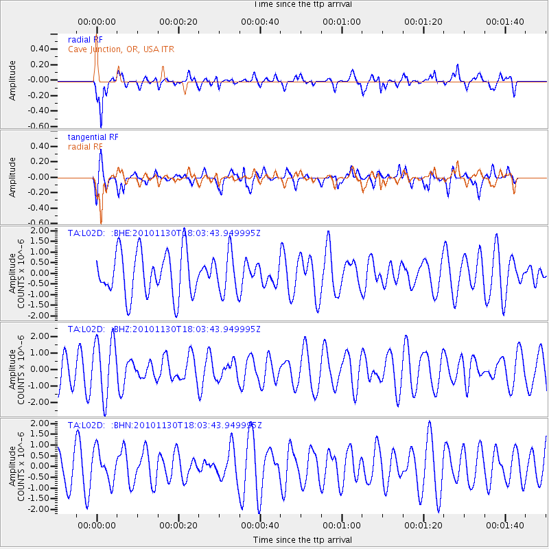
L02D Cave Junction, OR, USA - Earthquake Result Viewer
*The percent match for this event was below the threshold and hence no stack was calculated.
| Earthquake location: |
Kuril Islands |
| Earthquake latitude/longitude: |
48.9/154.9 |
| Earthquake time(UTC): |
2010/11/30 (334) 17:54:47 GMT |
| Earthquake Depth: |
35 km |
| Earthquake Magnitude: |
5.7 MW, 5.2 MS, 5.4 MB, 5.6 MW |
| Earthquake Catalog/Contributor: |
WHDF/NEIC |
|
| Network: |
TA USArray Transportable Network (new EarthScope stations) |
| Station: |
L02D Cave Junction, OR, USA |
| Lat/Lon: |
42.16 N/123.60 W |
| Elevation: |
458 m |
|
| Distance: |
54.9 deg |
| Az: |
64.024 deg |
| Baz: |
307.109 deg |
| Ray Param: |
$rayparam |
*The percent match for this event was below the threshold and hence was not used in the summary stack. |
|
| Radial Match: |
62.609283 % |
| Radial Bump: |
400 |
| Transverse Match: |
42.418842 % |
| Transverse Bump: |
400 |
| SOD ConfigId: |
343951 |
| Insert Time: |
2011-05-24 01:49:49.166 +0000 |
| GWidth: |
2.5 |
| Max Bumps: |
400 |
| Tol: |
0.001 |
|
Signal To Noise
| Channel | StoN | STA | LTA |
| TA:L02D: :BHZ:20101130T18:03:43.949995Z | 2.342056 | 1.7816537E-6 | 7.6072206E-7 |
| TA:L02D: :BHN:20101130T18:03:43.949995Z | 0.87185323 | 7.4161306E-7 | 8.506169E-7 |
| TA:L02D: :BHE:20101130T18:03:43.949995Z | 0.9327152 | 9.726308E-7 | 1.042795E-6 |
| Arrivals |
| Ps | |
| PpPs | |
| PsPs/PpSs | |


