You are here: Home > Network List > TA - USArray Transportable Network (new EarthScope stations) Stations List
> Station X35A Drake, OK, USA > Earthquake Result Viewer
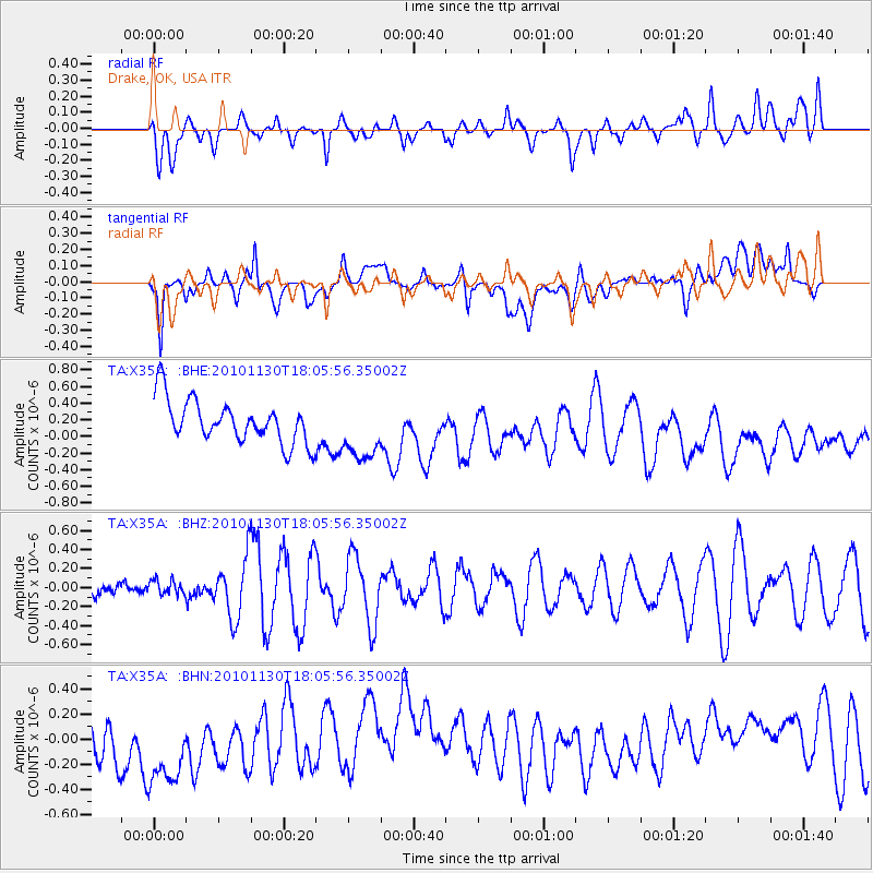
X35A Drake, OK, USA - Earthquake Result Viewer
*The percent match for this event was below the threshold and hence no stack was calculated.
| Earthquake location: |
Kuril Islands |
| Earthquake latitude/longitude: |
48.9/154.9 |
| Earthquake time(UTC): |
2010/11/30 (334) 17:54:47 GMT |
| Earthquake Depth: |
35 km |
| Earthquake Magnitude: |
5.7 MW, 5.2 MS, 5.4 MB, 5.6 MW |
| Earthquake Catalog/Contributor: |
WHDF/NEIC |
|
| Network: |
TA USArray Transportable Network (new EarthScope stations) |
| Station: |
X35A Drake, OK, USA |
| Lat/Lon: |
34.40 N/96.97 W |
| Elevation: |
300 m |
|
| Distance: |
75.3 deg |
| Az: |
54.33 deg |
| Baz: |
319.607 deg |
| Ray Param: |
$rayparam |
*The percent match for this event was below the threshold and hence was not used in the summary stack. |
|
| Radial Match: |
48.67626 % |
| Radial Bump: |
400 |
| Transverse Match: |
31.477095 % |
| Transverse Bump: |
400 |
| SOD ConfigId: |
343951 |
| Insert Time: |
2011-05-24 01:51:49.301 +0000 |
| GWidth: |
2.5 |
| Max Bumps: |
400 |
| Tol: |
0.001 |
|
Signal To Noise
| Channel | StoN | STA | LTA |
| TA:X35A: :BHZ:20101130T18:05:56.35002Z | 0.37025228 | 7.704199E-8 | 2.0807973E-7 |
| TA:X35A: :BHN:20101130T18:05:56.35002Z | 1.8351319 | 4.7304127E-7 | 2.5776964E-7 |
| TA:X35A: :BHE:20101130T18:05:56.35002Z | 1.4186398 | 3.6861047E-7 | 2.5983374E-7 |
| Arrivals |
| Ps | |
| PpPs | |
| PsPs/PpSs | |


