You are here: Home > Network List > TA - USArray Transportable Network (new EarthScope stations) Stations List
> Station J01D Myrtle Point, OR, USA > Earthquake Result Viewer
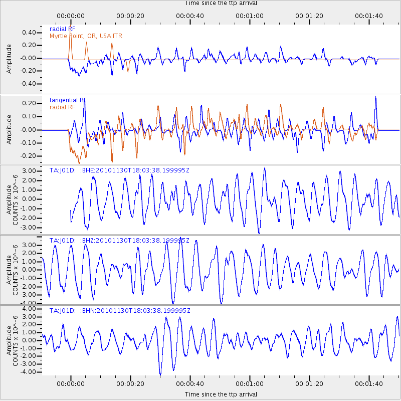
J01D Myrtle Point, OR, USA - Earthquake Result Viewer
*The percent match for this event was below the threshold and hence no stack was calculated.
| Earthquake location: |
Kuril Islands |
| Earthquake latitude/longitude: |
48.9/154.9 |
| Earthquake time(UTC): |
2010/11/30 (334) 17:54:47 GMT |
| Earthquake Depth: |
35 km |
| Earthquake Magnitude: |
5.7 MW, 5.2 MS, 5.4 MB, 5.6 MW |
| Earthquake Catalog/Contributor: |
WHDF/NEIC |
|
| Network: |
TA USArray Transportable Network (new EarthScope stations) |
| Station: |
J01D Myrtle Point, OR, USA |
| Lat/Lon: |
43.16 N/123.93 W |
| Elevation: |
131 m |
|
| Distance: |
54.1 deg |
| Az: |
63.215 deg |
| Baz: |
306.418 deg |
| Ray Param: |
$rayparam |
*The percent match for this event was below the threshold and hence was not used in the summary stack. |
|
| Radial Match: |
57.57584 % |
| Radial Bump: |
400 |
| Transverse Match: |
51.153015 % |
| Transverse Bump: |
400 |
| SOD ConfigId: |
343951 |
| Insert Time: |
2011-05-24 01:53:15.234 +0000 |
| GWidth: |
2.5 |
| Max Bumps: |
400 |
| Tol: |
0.001 |
|
Signal To Noise
| Channel | StoN | STA | LTA |
| TA:J01D: :BHZ:20101130T18:03:38.199995Z | 1.1606106 | 2.2241693E-6 | 1.9163788E-6 |
| TA:J01D: :BHN:20101130T18:03:38.199995Z | 1.0244987 | 9.85939E-7 | 9.623624E-7 |
| TA:J01D: :BHE:20101130T18:03:38.199995Z | 0.6269086 | 9.712951E-7 | 1.5493407E-6 |
| Arrivals |
| Ps | |
| PpPs | |
| PsPs/PpSs | |


