You are here: Home > Network List > IU - Global Seismograph Network (GSN - IRIS/USGS) Stations List
> Station FURI Mt. Furi, Ethiopia > Earthquake Result Viewer
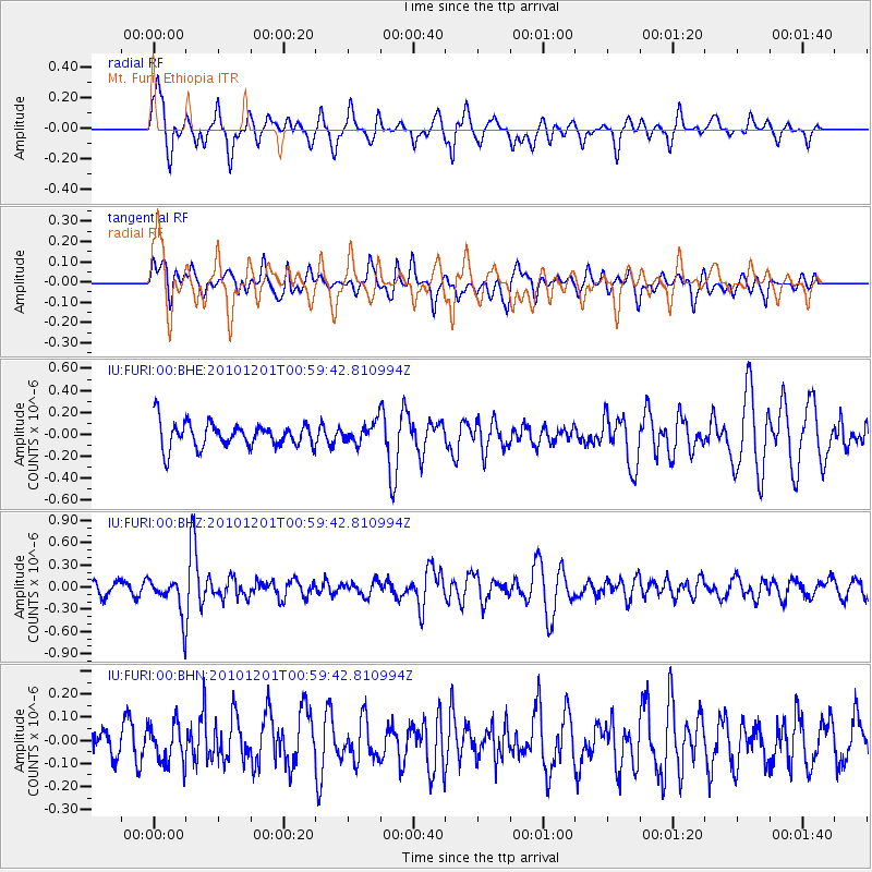
FURI Mt. Furi, Ethiopia - Earthquake Result Viewer
*The percent match for this event was below the threshold and hence no stack was calculated.
| Earthquake location: |
Northern Sumatra, Indonesia |
| Earthquake latitude/longitude: |
2.7/99.0 |
| Earthquake time(UTC): |
2010/12/01 (335) 00:50:21 GMT |
| Earthquake Depth: |
160 km |
| Earthquake Magnitude: |
5.5 MW, 5.4 MB, 5.5 MW |
| Earthquake Catalog/Contributor: |
WHDF/NEIC |
|
| Network: |
IU Global Seismograph Network (GSN - IRIS/USGS) |
| Station: |
FURI Mt. Furi, Ethiopia |
| Lat/Lon: |
8.90 N/38.68 E |
| Elevation: |
2570 m |
|
| Distance: |
60.3 deg |
| Az: |
278.652 deg |
| Baz: |
91.968 deg |
| Ray Param: |
$rayparam |
*The percent match for this event was below the threshold and hence was not used in the summary stack. |
|
| Radial Match: |
64.63308 % |
| Radial Bump: |
400 |
| Transverse Match: |
54.52883 % |
| Transverse Bump: |
400 |
| SOD ConfigId: |
343951 |
| Insert Time: |
2011-05-24 02:32:04.798 +0000 |
| GWidth: |
2.5 |
| Max Bumps: |
400 |
| Tol: |
0.001 |
|
Signal To Noise
| Channel | StoN | STA | LTA |
| IU:FURI:00:BHZ:20101201T00:59:42.810994Z | 2.592014 | 2.6616243E-7 | 1.0268556E-7 |
| IU:FURI:00:BHN:20101201T00:59:42.810994Z | 1.0927738 | 8.54305E-8 | 7.817766E-8 |
| IU:FURI:00:BHE:20101201T00:59:42.810994Z | 0.8206362 | 9.300145E-8 | 1.13328475E-7 |
| Arrivals |
| Ps | |
| PpPs | |
| PsPs/PpSs | |


