You are here: Home > Network List > KN - Kyrgyz Seismic Telemetry Network Stations List
> Station TKM2 KN.TKM2 > Earthquake Result Viewer
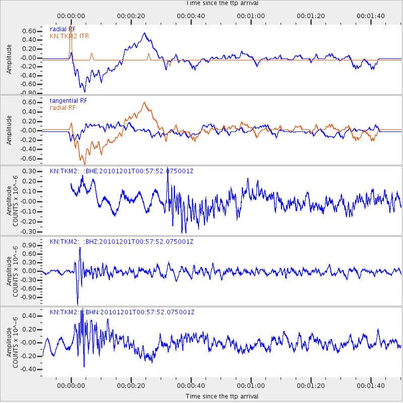
TKM2 KN.TKM2 - Earthquake Result Viewer
*The percent match for this event was below the threshold and hence no stack was calculated.
| Earthquake location: |
Northern Sumatra, Indonesia |
| Earthquake latitude/longitude: |
2.7/99.0 |
| Earthquake time(UTC): |
2010/12/01 (335) 00:50:21 GMT |
| Earthquake Depth: |
160 km |
| Earthquake Magnitude: |
5.5 MW, 5.4 MB, 5.5 MW |
| Earthquake Catalog/Contributor: |
WHDF/NEIC |
|
| Network: |
KN Kyrgyz Seismic Telemetry Network |
| Station: |
TKM2 KN.TKM2 |
| Lat/Lon: |
42.92 N/75.60 E |
| Elevation: |
2020 m |
|
| Distance: |
45.2 deg |
| Az: |
335.67 deg |
| Baz: |
145.928 deg |
| Ray Param: |
$rayparam |
*The percent match for this event was below the threshold and hence was not used in the summary stack. |
|
| Radial Match: |
43.041405 % |
| Radial Bump: |
400 |
| Transverse Match: |
30.190775 % |
| Transverse Bump: |
400 |
| SOD ConfigId: |
343951 |
| Insert Time: |
2011-05-24 02:37:16.566 +0000 |
| GWidth: |
2.5 |
| Max Bumps: |
400 |
| Tol: |
0.001 |
|
Signal To Noise
| Channel | StoN | STA | LTA |
| KN:TKM2: :BHZ:20101201T00:57:52.075001Z | 9.316351 | 3.835893E-7 | 4.1173774E-8 |
| KN:TKM2: :BHN:20101201T00:57:52.075001Z | 3.481033 | 2.5273349E-7 | 7.2603015E-8 |
| KN:TKM2: :BHE:20101201T00:57:52.075001Z | 1.3048904 | 1.1012177E-7 | 8.439159E-8 |
| Arrivals |
| Ps | |
| PpPs | |
| PsPs/PpSs | |


