You are here: Home > Network List > TX - Texas Seismological Network Stations List
> Station FW14 Avarado > Earthquake Result Viewer
FW14 Avarado - Earthquake Result Viewer
| Earthquake location: |
North Atlantic Ocean |
| Earthquake latitude/longitude: |
20.0/-61.1 |
| Earthquake time(UTC): |
2023/07/10 (191) 20:28:25 GMT |
| Earthquake Depth: |
10 km |
| Earthquake Magnitude: |
6.6 mww |
| Earthquake Catalog/Contributor: |
NEIC PDE/us |
|
| Network: |
TX Texas Seismological Network |
| Station: |
FW14 Avarado |
| Lat/Lon: |
32.40 N/97.19 W |
| Elevation: |
219 m |
|
| Distance: |
34.5 deg |
| Az: |
298.339 deg |
| Baz: |
101.952 deg |
| Ray Param: |
0.07772049 |
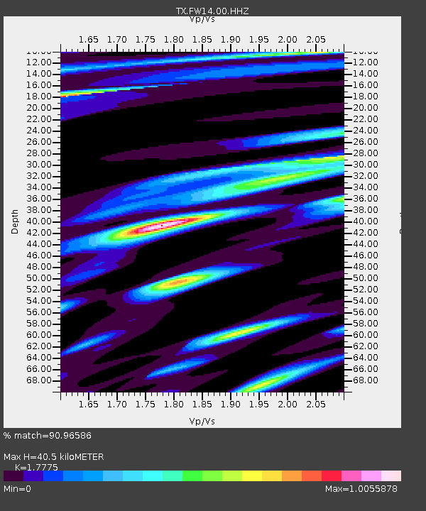
| Estimated Moho Depth: |
40.5 km |
| Estimated Crust Vp/Vs: |
1.78 |
| Assumed Crust Vp: |
6.38 km/s |
| Estimated Crust Vs: |
3.59 km/s |
| Estimated Crust Poisson's Ratio: |
0.27 |
|
| Radial Match: |
90.96586 % |
| Radial Bump: |
362 |
| Transverse Match: |
84.83813 % |
| Transverse Bump: |
335 |
| SOD ConfigId: |
34243671 |
| Insert Time: |
2024-05-05 02:33:28.643 +0000 |
| GWidth: |
2.5 |
| Max Bumps: |
400 |
| Tol: |
0.001 |
|

Signal To Noise
| Channel | StoN | STA | LTA |
| TX:FW14:00:HHZ:20230710T20:34:43.053011Z | 11.552114 | 2.200895E-6 | 1.9051882E-7 |
| TX:FW14:00:HHN:20230710T20:34:43.053011Z | 1.366681 | 4.217543E-7 | 3.0859746E-7 |
| TX:FW14:00:HHE:20230710T20:34:43.053011Z | 5.377097 | 1.3002201E-6 | 2.4180707E-7 |
| Arrivals |
| Ps | 5.3 SECOND |
| PpPs | 16 SECOND |
| PsPs/PpSs | 22 SECOND |


