You are here: Home > Network List > TX - Texas Seismological Network Stations List
> Station DRIO Del Rio > Earthquake Result Viewer
DRIO Del Rio - Earthquake Result Viewer
| Earthquake location: |
Alaska Peninsula |
| Earthquake latitude/longitude: |
54.5/-160.8 |
| Earthquake time(UTC): |
2023/07/16 (197) 06:48:21 GMT |
| Earthquake Depth: |
21 km |
| Earthquake Magnitude: |
7.3 Mi |
| Earthquake Catalog/Contributor: |
NEIC PDE/at |
|
| Network: |
TX Texas Seismological Network |
| Station: |
DRIO Del Rio |
| Lat/Lon: |
29.42 N/100.62 W |
| Elevation: |
354 m |
|
| Distance: |
49.5 deg |
| Az: |
95.075 deg |
| Baz: |
318.231 deg |
| Ray Param: |
0.06868128 |
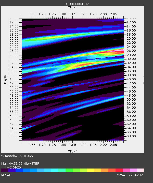
| Estimated Moho Depth: |
25.25 km |
| Estimated Crust Vp/Vs: |
2.09 |
| Assumed Crust Vp: |
6.12 km/s |
| Estimated Crust Vs: |
2.925 km/s |
| Estimated Crust Poisson's Ratio: |
0.35 |
|
| Radial Match: |
96.31065 % |
| Radial Bump: |
233 |
| Transverse Match: |
82.53456 % |
| Transverse Bump: |
400 |
| SOD ConfigId: |
34243671 |
| Insert Time: |
2024-05-05 03:14:41.303 +0000 |
| GWidth: |
2.5 |
| Max Bumps: |
400 |
| Tol: |
0.001 |
|

Signal To Noise
| Channel | StoN | STA | LTA |
| TX:DRIO:00:HHZ:20230716T06:56:38.071991Z | 2.4877927 | 2.7875777E-7 | 1.1205025E-7 |
| TX:DRIO:00:HHN:20230716T06:56:38.071991Z | 1.1692193 | 1.6307949E-7 | 1.3947725E-7 |
| TX:DRIO:00:HHE:20230716T06:56:38.071991Z | 1.2927862 | 3.19467E-7 | 2.4711508E-7 |
| Arrivals |
| Ps | 4.7 SECOND |
| PpPs | 12 SECOND |
| PsPs/PpSs | 17 SECOND |


