You are here: Home > Network List > TX - Texas Seismological Network Stations List
> Station FW13 Cleburne > Earthquake Result Viewer
FW13 Cleburne - Earthquake Result Viewer
| Earthquake location: |
Alaska Peninsula |
| Earthquake latitude/longitude: |
54.5/-160.8 |
| Earthquake time(UTC): |
2023/07/16 (197) 06:48:21 GMT |
| Earthquake Depth: |
21 km |
| Earthquake Magnitude: |
7.3 Mi |
| Earthquake Catalog/Contributor: |
NEIC PDE/at |
|
| Network: |
TX Texas Seismological Network |
| Station: |
FW13 Cleburne |
| Lat/Lon: |
32.35 N/97.43 W |
| Elevation: |
259 m |
|
| Distance: |
49.2 deg |
| Az: |
89.808 deg |
| Baz: |
316.425 deg |
| Ray Param: |
0.068847895 |
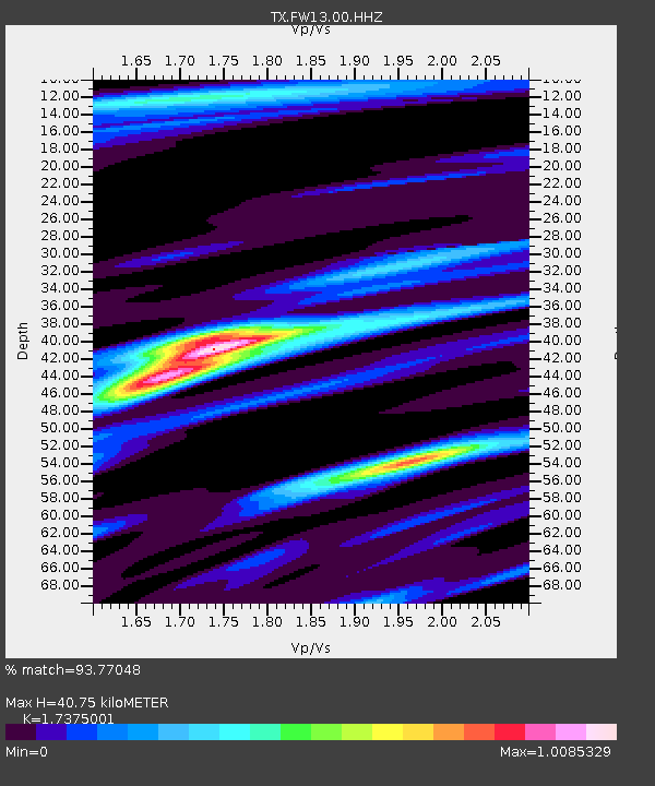
| Estimated Moho Depth: |
40.75 km |
| Estimated Crust Vp/Vs: |
1.74 |
| Assumed Crust Vp: |
6.38 km/s |
| Estimated Crust Vs: |
3.672 km/s |
| Estimated Crust Poisson's Ratio: |
0.25 |
|
| Radial Match: |
93.77048 % |
| Radial Bump: |
341 |
| Transverse Match: |
78.02625 % |
| Transverse Bump: |
400 |
| SOD ConfigId: |
34243671 |
| Insert Time: |
2024-05-05 03:14:52.420 +0000 |
| GWidth: |
2.5 |
| Max Bumps: |
400 |
| Tol: |
0.001 |
|

Signal To Noise
| Channel | StoN | STA | LTA |
| TX:FW13:00:HHZ:20230716T06:56:35.941986Z | 6.0060325 | 9.0541045E-7 | 1.5075017E-7 |
| TX:FW13:00:HHN:20230716T06:56:35.941986Z | 1.7867007 | 3.876927E-7 | 2.1698803E-7 |
| TX:FW13:00:HHE:20230716T06:56:35.941986Z | 2.0475426 | 5.003501E-7 | 2.4436613E-7 |
| Arrivals |
| Ps | 5.0 SECOND |
| PpPs | 16 SECOND |
| PsPs/PpSs | 21 SECOND |


