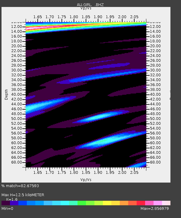
GIRL Giralia, Western Australia - Earthquake Result Viewer

Earthquake location: New Britain Region, P.N.G.
Earthquake latitude/longitude: -6.0/150.0
Earthquake time(UTC): 2010/12/02 (336) 03:12:09 GMT
Earthquake Depth: 33 km
Earthquake Magnitude: 5.9 MB, 6.7 MS, 6.6 MW, 6.6 MW
Earthquake Catalog/Contributor: WHDF/NEIC
Network: AU Australian Seismological Centre
Station: GIRL Giralia, Western Australia
Lat/Lon: 22.64 S/114.23 E
Elevation: 111 m
Distance: 38.2 deg
Az: 240.7 deg
Baz: 69.861 deg
Ray Param: 0.075617686
Estimated Moho Depth: 12.5 km
Estimated Crust Vp/Vs: 1.60
Assumed Crust Vp: 6.285 km/s
Estimated Crust Vs: 3.928 km/s
Estimated Crust Poisson's Ratio: 0.18
Radial Match: 82.67593 %
Radial Bump: 327
Transverse Match: 71.51423 %
Transverse Bump: 400
SOD ConfigId: 343951
Insert Time: 2011-05-24 03:36:50.811 +0000
GWidth: 2.5
Max Bumps: 400
Tol: 0.001

Signal To Noise

ChannelStoNSTALTA
AU:GIRL: :BHZ:20101202T03:18:56.219994Z2.65170572.7062927E-61.0205856E-6
AU:GIRL: :BHN:20101202T03:18:56.219994Z0.78488072.1686346E-62.7630117E-6
AU:GIRL: :BHE:20101202T03:18:56.219994Z1.03780262.7928882E-62.6911555E-6
Arrivals
Ps1.3 SECOND
PpPs4.8 SECOND
PsPs/PpSs6.1 SECOND