You are here: Home > Network List > UW - Pacific Northwest Regional Seismic Network Stations List
> Station HSR South Ridge, Mt. St. Helens, WA, USA > Earthquake Result Viewer
HSR South Ridge, Mt. St. Helens, WA, USA - Earthquake Result Viewer
| Earthquake location: |
Vanuatu Islands |
| Earthquake latitude/longitude: |
-14.8/167.9 |
| Earthquake time(UTC): |
2023/07/26 (207) 12:44:35 GMT |
| Earthquake Depth: |
13 km |
| Earthquake Magnitude: |
6.4 mww |
| Earthquake Catalog/Contributor: |
NEIC PDE/us |
|
| Network: |
UW Pacific Northwest Regional Seismic Network |
| Station: |
HSR South Ridge, Mt. St. Helens, WA, USA |
| Lat/Lon: |
46.17 N/122.18 W |
| Elevation: |
1720 m |
|
| Distance: |
87.2 deg |
| Az: |
40.794 deg |
| Baz: |
245.451 deg |
| Ray Param: |
0.04349807 |
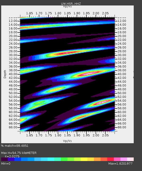
| Estimated Moho Depth: |
54.75 km |
| Estimated Crust Vp/Vs: |
2.03 |
| Assumed Crust Vp: |
6.566 km/s |
| Estimated Crust Vs: |
3.239 km/s |
| Estimated Crust Poisson's Ratio: |
0.34 |
|
| Radial Match: |
89.4851 % |
| Radial Bump: |
400 |
| Transverse Match: |
90.6277 % |
| Transverse Bump: |
400 |
| SOD ConfigId: |
34243671 |
| Insert Time: |
2024-05-05 05:34:03.155 +0000 |
| GWidth: |
2.5 |
| Max Bumps: |
400 |
| Tol: |
0.001 |
|

Signal To Noise
| Channel | StoN | STA | LTA |
| UW:HSR: :HHZ:20230726T12:56:49.879994Z | 13.866969 | 1.1828517E-6 | 8.5299945E-8 |
| UW:HSR: :HHN:20230726T12:56:49.879994Z | 1.5047452 | 2.5915415E-7 | 1.722246E-7 |
| UW:HSR: :HHE:20230726T12:56:49.879994Z | 2.176454 | 3.374028E-7 | 1.5502408E-7 |
| Arrivals |
| Ps | 8.7 SECOND |
| PpPs | 25 SECOND |
| PsPs/PpSs | 33 SECOND |


