You are here: Home > Network List > AZ - ANZA Regional Network Stations List
> Station FRD AZ.FRD > Earthquake Result Viewer
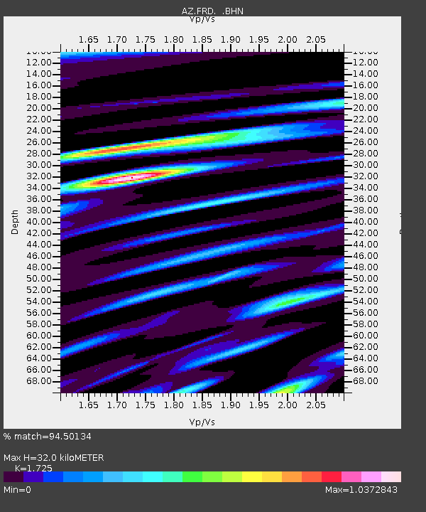
FRD AZ.FRD - Earthquake Result Viewer
| Earthquake location: |
Chile-Bolivia Border Region |
| Earthquake latitude/longitude: |
-21.7/-68.3 |
| Earthquake time(UTC): |
2002/03/28 (087) 04:56:22 GMT |
| Earthquake Depth: |
125 km |
| Earthquake Magnitude: |
6.1 MB, 6.5 MW, 6.5 MW |
| Earthquake Catalog/Contributor: |
WHDF/NEIC |
|
| Network: |
AZ ANZA Regional Network |
| Station: |
FRD AZ.FRD |
| Lat/Lon: |
33.49 N/116.60 W |
| Elevation: |
1164 m |
|
| Distance: |
71.6 deg |
| Az: |
318.907 deg |
| Baz: |
132.972 deg |
| Ray Param: |
0.053903133 |
| Estimated Moho Depth: |
32.0 km |
| Estimated Crust Vp/Vs: |
1.73 |
| Assumed Crust Vp: |
6.264 km/s |
| Estimated Crust Vs: |
3.631 km/s |
| Estimated Crust Poisson's Ratio: |
0.25 |
|
| Radial Match: |
94.50134 % |
| Radial Bump: |
400 |
| Transverse Match: |
89.27101 % |
| Transverse Bump: |
400 |
| SOD ConfigId: |
32974 |
| Insert Time: |
2010-02-26 19:11:06.068 +0000 |
| GWidth: |
2.5 |
| Max Bumps: |
400 |
| Tol: |
0.001 |
|

Signal To Noise
| Channel | StoN | STA | LTA |
| AZ:FRD: :BHN:20020328T05:06:59.199011Z | 3.0338964 | 3.0185404E-7 | 9.9493846E-8 |
| AZ:FRD: :BHE:20020328T05:06:59.199011Z | 2.2913969 | 4.2208103E-7 | 1.842025E-7 |
| AZ:FRD: :BHZ:20020328T05:06:59.199011Z | 10.2575445 | 1.7327002E-6 | 1.6891958E-7 |
| Arrivals |
| Ps | 3.8 SECOND |
| PpPs | 13 SECOND |
| PsPs/PpSs | 17 SECOND |


