You are here: Home > Network List > TA - USArray Transportable Network (new EarthScope stations) Stations List
> Station O03D Paynes Creek, CA, USA > Earthquake Result Viewer
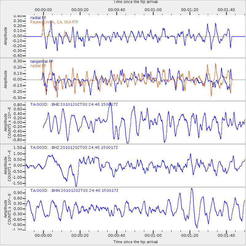
O03D Paynes Creek, CA, USA - Earthquake Result Viewer
*The percent match for this event was below the threshold and hence no stack was calculated.
| Earthquake location: |
New Britain Region, P.N.G. |
| Earthquake latitude/longitude: |
-6.0/150.0 |
| Earthquake time(UTC): |
2010/12/02 (336) 03:12:09 GMT |
| Earthquake Depth: |
33 km |
| Earthquake Magnitude: |
5.9 MB, 6.7 MS, 6.6 MW, 6.6 MW |
| Earthquake Catalog/Contributor: |
WHDF/NEIC |
|
| Network: |
TA USArray Transportable Network (new EarthScope stations) |
| Station: |
O03D Paynes Creek, CA, USA |
| Lat/Lon: |
40.29 N/121.80 W |
| Elevation: |
968 m |
|
| Distance: |
92.5 deg |
| Az: |
49.926 deg |
| Baz: |
264.294 deg |
| Ray Param: |
$rayparam |
*The percent match for this event was below the threshold and hence was not used in the summary stack. |
|
| Radial Match: |
57.549408 % |
| Radial Bump: |
400 |
| Transverse Match: |
57.424236 % |
| Transverse Bump: |
400 |
| SOD ConfigId: |
343951 |
| Insert Time: |
2011-05-24 04:13:16.266 +0000 |
| GWidth: |
2.5 |
| Max Bumps: |
400 |
| Tol: |
0.001 |
|
Signal To Noise
| Channel | StoN | STA | LTA |
| TA:O03D: :BHZ:20101202T03:24:46.150017Z | 2.9315326 | 6.1743873E-7 | 2.1061977E-7 |
| TA:O03D: :BHN:20101202T03:24:46.150017Z | 1.045433 | 3.262618E-7 | 3.1208296E-7 |
| TA:O03D: :BHE:20101202T03:24:46.150017Z | 0.38046122 | 1.2015352E-7 | 3.1581015E-7 |
| Arrivals |
| Ps | |
| PpPs | |
| PsPs/PpSs | |


