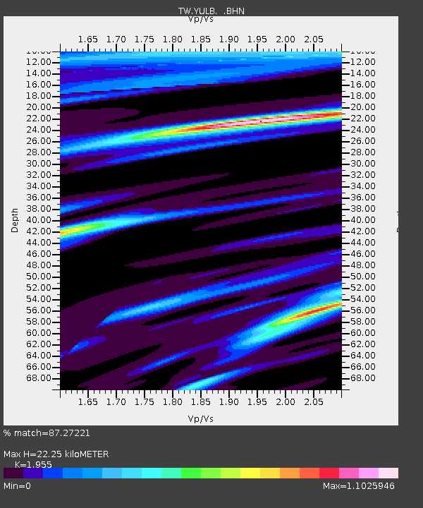
YULB YU-LI - Earthquake Result Viewer

Earthquake location: New Britain Region, P.N.G.
Earthquake latitude/longitude: -6.0/150.0
Earthquake time(UTC): 2010/12/02 (336) 03:12:09 GMT
Earthquake Depth: 33 km
Earthquake Magnitude: 5.9 MB, 6.7 MS, 6.6 MW, 6.6 MW
Earthquake Catalog/Contributor: WHDF/NEIC
Network: TW Broadband Array in Taiwan for Seismology
Station: YULB YU-LI
Lat/Lon: 23.39 N/121.30 E
Elevation: 295 m
Distance: 40.5 deg
Az: 317.212 deg
Baz: 132.664 deg
Ray Param: 0.07431715
Estimated Moho Depth: 22.25 km
Estimated Crust Vp/Vs: 1.96
Assumed Crust Vp: 6.461 km/s
Estimated Crust Vs: 3.305 km/s
Estimated Crust Poisson's Ratio: 0.32
Radial Match: 87.27221 %
Radial Bump: 338
Transverse Match: 80.949005 %
Transverse Bump: 400
SOD ConfigId: 343951
Insert Time: 2011-05-24 04:15:54.054 +0000
GWidth: 2.5
Max Bumps: 400
Tol: 0.001

Signal To Noise

ChannelStoNSTALTA
TW:YULB: :BHZ:20101202T03:19:14.920006Z10.6225561.5821333E-61.4894094E-7
TW:YULB: :BHN:20101202T03:19:14.920006Z5.28638037.180425E-71.3582877E-7
TW:YULB: :BHE:20101202T03:19:14.920006Z4.0345696.684351E-71.6567697E-7
Arrivals
Ps3.5 SECOND
PpPs9.5 SECOND
PsPs/PpSs13 SECOND