You are here: Home > Network List > US - United States National Seismic Network Stations List
> Station HAWA Hanford, Washington, USA > Earthquake Result Viewer
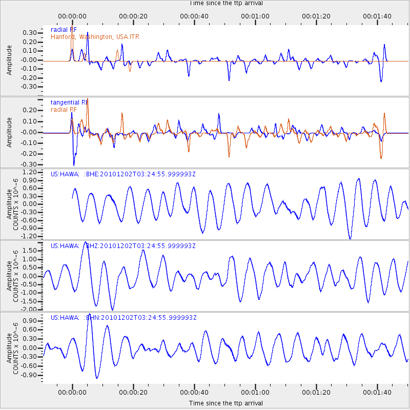
HAWA Hanford, Washington, USA - Earthquake Result Viewer
*The percent match for this event was below the threshold and hence no stack was calculated.
| Earthquake location: |
New Britain Region, P.N.G. |
| Earthquake latitude/longitude: |
-6.0/150.0 |
| Earthquake time(UTC): |
2010/12/02 (336) 03:12:09 GMT |
| Earthquake Depth: |
33 km |
| Earthquake Magnitude: |
5.9 MB, 6.7 MS, 6.6 MW, 6.6 MW |
| Earthquake Catalog/Contributor: |
WHDF/NEIC |
|
| Network: |
US United States National Seismic Network |
| Station: |
HAWA Hanford, Washington, USA |
| Lat/Lon: |
46.39 N/119.53 W |
| Elevation: |
364 m |
|
| Distance: |
94.6 deg |
| Az: |
43.978 deg |
| Baz: |
266.218 deg |
| Ray Param: |
$rayparam |
*The percent match for this event was below the threshold and hence was not used in the summary stack. |
|
| Radial Match: |
50.82257 % |
| Radial Bump: |
317 |
| Transverse Match: |
47.029972 % |
| Transverse Bump: |
400 |
| SOD ConfigId: |
343951 |
| Insert Time: |
2011-05-24 04:17:16.159 +0000 |
| GWidth: |
2.5 |
| Max Bumps: |
400 |
| Tol: |
0.001 |
|
Signal To Noise
| Channel | StoN | STA | LTA |
| US:HAWA: :BHZ:20101202T03:24:55.999993Z | 4.4569254 | 1.1465855E-6 | 2.572593E-7 |
| US:HAWA: :BHN:20101202T03:24:55.999993Z | 1.1407111 | 3.955127E-7 | 3.4672468E-7 |
| US:HAWA: :BHE:20101202T03:24:55.999993Z | 1.0643234 | 4.4217873E-7 | 4.1545522E-7 |
| Arrivals |
| Ps | |
| PpPs | |
| PsPs/PpSs | |


