You are here: Home > Network List > UW - Pacific Northwest Regional Seismic Network Stations List
> Station WOLL Wollman Farm, Schrag, WA, USA > Earthquake Result Viewer
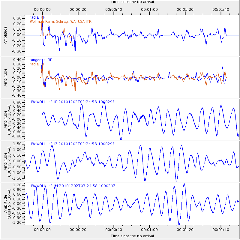
WOLL Wollman Farm, Schrag, WA, USA - Earthquake Result Viewer
*The percent match for this event was below the threshold and hence no stack was calculated.
| Earthquake location: |
New Britain Region, P.N.G. |
| Earthquake latitude/longitude: |
-6.0/150.0 |
| Earthquake time(UTC): |
2010/12/02 (336) 03:12:09 GMT |
| Earthquake Depth: |
33 km |
| Earthquake Magnitude: |
5.9 MB, 6.7 MS, 6.6 MW, 6.6 MW |
| Earthquake Catalog/Contributor: |
WHDF/NEIC |
|
| Network: |
UW Pacific Northwest Regional Seismic Network |
| Station: |
WOLL Wollman Farm, Schrag, WA, USA |
| Lat/Lon: |
47.06 N/118.92 W |
| Elevation: |
385 m |
|
| Distance: |
95.1 deg |
| Az: |
43.338 deg |
| Baz: |
266.717 deg |
| Ray Param: |
$rayparam |
*The percent match for this event was below the threshold and hence was not used in the summary stack. |
|
| Radial Match: |
64.6487 % |
| Radial Bump: |
400 |
| Transverse Match: |
44.44084 % |
| Transverse Bump: |
312 |
| SOD ConfigId: |
343951 |
| Insert Time: |
2011-05-24 04:20:17.912 +0000 |
| GWidth: |
2.5 |
| Max Bumps: |
400 |
| Tol: |
0.001 |
|
Signal To Noise
| Channel | StoN | STA | LTA |
| UW:WOLL: :BHZ:20101202T03:24:58.100029Z | 1.2767085 | 6.473248E-7 | 5.070263E-7 |
| UW:WOLL: :BHN:20101202T03:24:58.100029Z | 2.0702095 | 8.2398435E-7 | 3.9801978E-7 |
| UW:WOLL: :BHE:20101202T03:24:58.100029Z | 1.4157064 | 4.1671106E-7 | 2.943485E-7 |
| Arrivals |
| Ps | |
| PpPs | |
| PsPs/PpSs | |


