You are here: Home > Network List > BK - Berkeley Digital Seismograph Network Stations List
> Station SAO San Andreas Geophysical Obs., Hollister, CA, USA > Earthquake Result Viewer
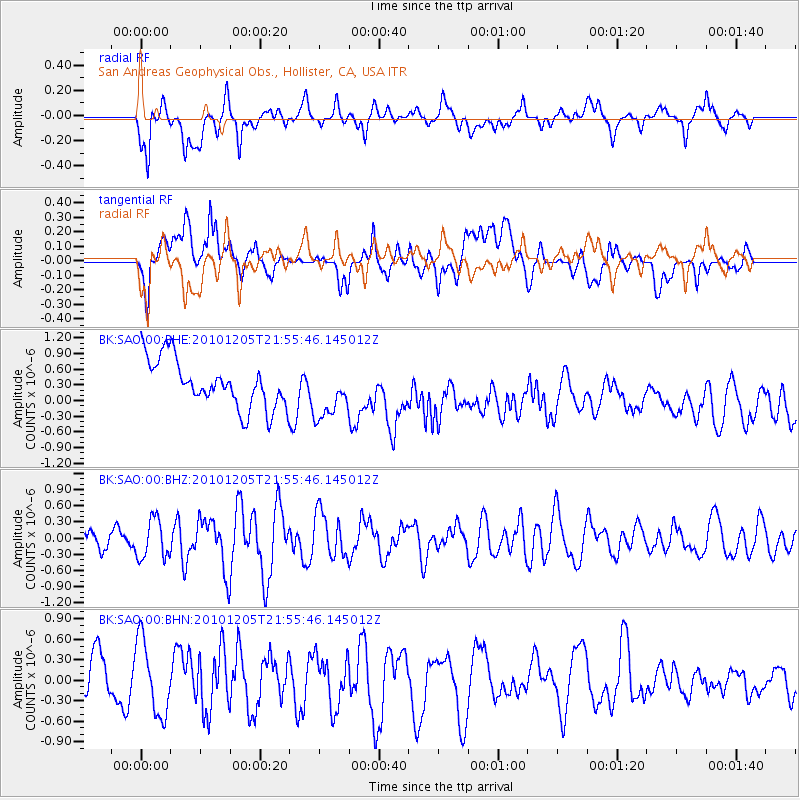
SAO San Andreas Geophysical Obs., Hollister, CA, USA - Earthquake Result Viewer
*The percent match for this event was below the threshold and hence no stack was calculated.
| Earthquake location: |
Southeast Of Easter Island |
| Earthquake latitude/longitude: |
-36.2/-100.8 |
| Earthquake time(UTC): |
2010/12/05 (339) 21:44:35 GMT |
| Earthquake Depth: |
13 km |
| Earthquake Magnitude: |
5.5 MB, 5.5 MS, 5.9 MW, 5.9 MW |
| Earthquake Catalog/Contributor: |
WHDF/NEIC |
|
| Network: |
BK Berkeley Digital Seismograph Network |
| Station: |
SAO San Andreas Geophysical Obs., Hollister, CA, USA |
| Lat/Lon: |
36.76 N/121.45 W |
| Elevation: |
317 m |
|
| Distance: |
75.1 deg |
| Az: |
342.984 deg |
| Baz: |
162.863 deg |
| Ray Param: |
$rayparam |
*The percent match for this event was below the threshold and hence was not used in the summary stack. |
|
| Radial Match: |
53.69372 % |
| Radial Bump: |
400 |
| Transverse Match: |
56.577656 % |
| Transverse Bump: |
400 |
| SOD ConfigId: |
343951 |
| Insert Time: |
2011-05-24 04:26:14.646 +0000 |
| GWidth: |
2.5 |
| Max Bumps: |
400 |
| Tol: |
0.001 |
|
Signal To Noise
| Channel | StoN | STA | LTA |
| BK:SAO:00:BHZ:20101205T21:55:46.145012Z | 1.9676586 | 3.6521757E-7 | 1.8561023E-7 |
| BK:SAO:00:BHN:20101205T21:55:46.145012Z | 2.0340252 | 5.528578E-7 | 2.718048E-7 |
| BK:SAO:00:BHE:20101205T21:55:46.145012Z | 1.1053163 | 5.023112E-7 | 4.544502E-7 |
| Arrivals |
| Ps | |
| PpPs | |
| PsPs/PpSs | |


