You are here: Home > Network List > CI - Caltech Regional Seismic Network Stations List
> Station BAR Barrett, Tecate, CA, USA > Earthquake Result Viewer
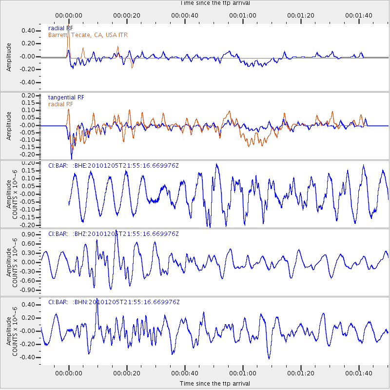
BAR Barrett, Tecate, CA, USA - Earthquake Result Viewer
*The percent match for this event was below the threshold and hence no stack was calculated.
| Earthquake location: |
Southeast Of Easter Island |
| Earthquake latitude/longitude: |
-36.2/-100.8 |
| Earthquake time(UTC): |
2010/12/05 (339) 21:44:35 GMT |
| Earthquake Depth: |
13 km |
| Earthquake Magnitude: |
5.5 MB, 5.5 MS, 5.9 MW, 5.9 MW |
| Earthquake Catalog/Contributor: |
WHDF/NEIC |
|
| Network: |
CI Caltech Regional Seismic Network |
| Station: |
BAR Barrett, Tecate, CA, USA |
| Lat/Lon: |
32.68 N/116.67 W |
| Elevation: |
521 m |
|
| Distance: |
70.1 deg |
| Az: |
345.828 deg |
| Baz: |
166.424 deg |
| Ray Param: |
$rayparam |
*The percent match for this event was below the threshold and hence was not used in the summary stack. |
|
| Radial Match: |
41.438705 % |
| Radial Bump: |
400 |
| Transverse Match: |
82.90331 % |
| Transverse Bump: |
400 |
| SOD ConfigId: |
343951 |
| Insert Time: |
2011-05-24 04:27:57.734 +0000 |
| GWidth: |
2.5 |
| Max Bumps: |
400 |
| Tol: |
0.001 |
|
Signal To Noise
| Channel | StoN | STA | LTA |
| CI:BAR: :BHZ:20101205T21:55:16.669976Z | 0.9527988 | 2.0908259E-7 | 2.1944045E-7 |
| CI:BAR: :BHN:20101205T21:55:16.669976Z | 0.8296671 | 9.880778E-8 | 1.1909329E-7 |
| CI:BAR: :BHE:20101205T21:55:16.669976Z | 0.40911582 | 3.8189725E-8 | 9.3346976E-8 |
| Arrivals |
| Ps | |
| PpPs | |
| PsPs/PpSs | |


