You are here: Home > Network List > GT - Global Telemetered Seismograph Network (USAF/USGS) Stations List
> Station LPAZ La Paz , Bolivia > Earthquake Result Viewer
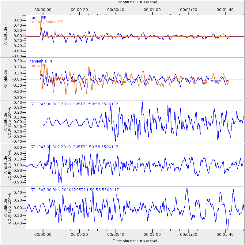
LPAZ La Paz , Bolivia - Earthquake Result Viewer
*The percent match for this event was below the threshold and hence no stack was calculated.
| Earthquake location: |
Southeast Of Easter Island |
| Earthquake latitude/longitude: |
-36.2/-100.8 |
| Earthquake time(UTC): |
2010/12/05 (339) 21:44:35 GMT |
| Earthquake Depth: |
13 km |
| Earthquake Magnitude: |
5.5 MB, 5.5 MS, 5.9 MW, 5.9 MW |
| Earthquake Catalog/Contributor: |
WHDF/NEIC |
|
| Network: |
GT Global Telemetered Seismograph Network (USAF/USGS) |
| Station: |
LPAZ La Paz , Bolivia |
| Lat/Lon: |
16.17 S/68.08 W |
| Elevation: |
4817 m |
|
| Distance: |
35.3 deg |
| Az: |
64.156 deg |
| Baz: |
229.222 deg |
| Ray Param: |
$rayparam |
*The percent match for this event was below the threshold and hence was not used in the summary stack. |
|
| Radial Match: |
62.03457 % |
| Radial Bump: |
400 |
| Transverse Match: |
42.12761 % |
| Transverse Bump: |
400 |
| SOD ConfigId: |
343951 |
| Insert Time: |
2011-05-24 04:33:49.686 +0000 |
| GWidth: |
2.5 |
| Max Bumps: |
400 |
| Tol: |
0.001 |
|
Signal To Noise
| Channel | StoN | STA | LTA |
| GT:LPAZ:00:BHZ:20101205T21:50:58.550011Z | 3.1143246 | 3.2468554E-7 | 1.0425552E-7 |
| GT:LPAZ:00:BHN:20101205T21:50:58.550011Z | 2.03874 | 1.2139121E-7 | 5.9542277E-8 |
| GT:LPAZ:00:BHE:20101205T21:50:58.550011Z | 1.9141805 | 9.5807884E-8 | 5.0051646E-8 |
| Arrivals |
| Ps | |
| PpPs | |
| PsPs/PpSs | |


