You are here: Home > Network List > TA - USArray Transportable Network (new EarthScope stations) Stations List
> Station MSTX Muleshoe, TX, USA > Earthquake Result Viewer
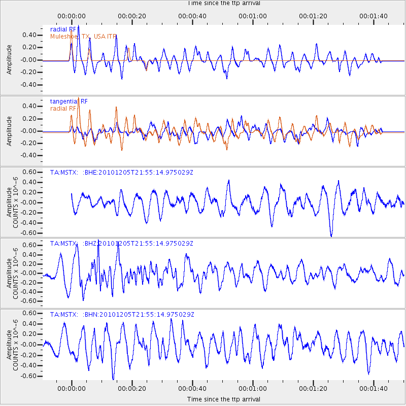
MSTX Muleshoe, TX, USA - Earthquake Result Viewer
*The percent match for this event was below the threshold and hence no stack was calculated.
| Earthquake location: |
Southeast Of Easter Island |
| Earthquake latitude/longitude: |
-36.2/-100.8 |
| Earthquake time(UTC): |
2010/12/05 (339) 21:44:35 GMT |
| Earthquake Depth: |
13 km |
| Earthquake Magnitude: |
5.5 MB, 5.5 MS, 5.9 MW, 5.9 MW |
| Earthquake Catalog/Contributor: |
WHDF/NEIC |
|
| Network: |
TA USArray Transportable Network (new EarthScope stations) |
| Station: |
MSTX Muleshoe, TX, USA |
| Lat/Lon: |
33.97 N/102.77 W |
| Elevation: |
1167 m |
|
| Distance: |
69.9 deg |
| Az: |
358.277 deg |
| Baz: |
178.324 deg |
| Ray Param: |
$rayparam |
*The percent match for this event was below the threshold and hence was not used in the summary stack. |
|
| Radial Match: |
44.606724 % |
| Radial Bump: |
400 |
| Transverse Match: |
45.93746 % |
| Transverse Bump: |
400 |
| SOD ConfigId: |
343951 |
| Insert Time: |
2011-05-24 04:41:26.390 +0000 |
| GWidth: |
2.5 |
| Max Bumps: |
400 |
| Tol: |
0.001 |
|
Signal To Noise
| Channel | StoN | STA | LTA |
| TA:MSTX: :BHZ:20101205T21:55:14.975029Z | 2.5448296 | 3.8588033E-7 | 1.5163306E-7 |
| TA:MSTX: :BHN:20101205T21:55:14.975029Z | 0.8237694 | 2.0705754E-7 | 2.5135378E-7 |
| TA:MSTX: :BHE:20101205T21:55:14.975029Z | 1.1885885 | 1.6171315E-7 | 1.3605478E-7 |
| Arrivals |
| Ps | |
| PpPs | |
| PsPs/PpSs | |


