You are here: Home > Network List > IW - Intermountain West Stations List
> Station DLMT Dillon, Montana, USA > Earthquake Result Viewer
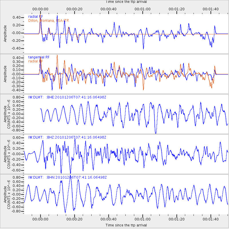
DLMT Dillon, Montana, USA - Earthquake Result Viewer
*The percent match for this event was below the threshold and hence no stack was calculated.
| Earthquake location: |
Near East Coast Of Honshu, Japan |
| Earthquake latitude/longitude: |
40.9/143.0 |
| Earthquake time(UTC): |
2010/12/06 (340) 07:30:32 GMT |
| Earthquake Depth: |
22 km |
| Earthquake Magnitude: |
5.6 MB, 5.4 MS, 5.7 MW, 5.7 MW |
| Earthquake Catalog/Contributor: |
WHDF/NEIC |
|
| Network: |
IW Intermountain West |
| Station: |
DLMT Dillon, Montana, USA |
| Lat/Lon: |
45.36 N/112.60 W |
| Elevation: |
1569 m |
|
| Distance: |
70.8 deg |
| Az: |
46.31 deg |
| Baz: |
308.975 deg |
| Ray Param: |
$rayparam |
*The percent match for this event was below the threshold and hence was not used in the summary stack. |
|
| Radial Match: |
53.36943 % |
| Radial Bump: |
331 |
| Transverse Match: |
59.527164 % |
| Transverse Bump: |
359 |
| SOD ConfigId: |
343951 |
| Insert Time: |
2011-05-24 05:32:01.549 +0000 |
| GWidth: |
2.5 |
| Max Bumps: |
400 |
| Tol: |
0.001 |
|
Signal To Noise
| Channel | StoN | STA | LTA |
| IW:DLMT: :BHZ:20101206T07:41:16.06498Z | 2.1284719 | 2.6771974E-7 | 1.2578025E-7 |
| IW:DLMT: :BHN:20101206T07:41:16.06498Z | 0.8771136 | 2.1346746E-7 | 2.4337493E-7 |
| IW:DLMT: :BHE:20101206T07:41:16.06498Z | 1.1747929 | 3.257688E-7 | 2.7729894E-7 |
| Arrivals |
| Ps | |
| PpPs | |
| PsPs/PpSs | |


