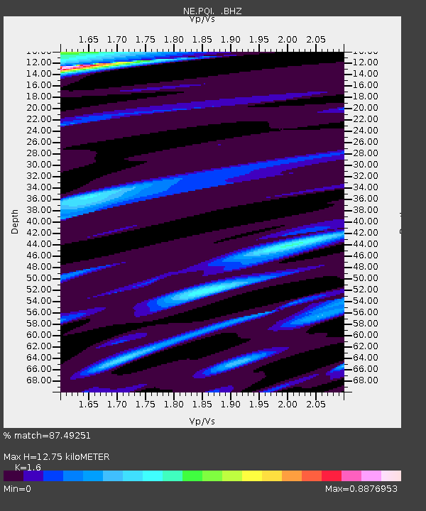
PQI Presque Isle, ME - Earthquake Result Viewer
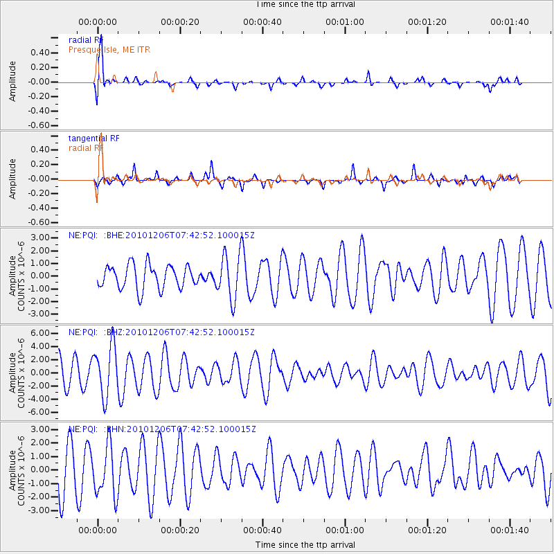
Earthquake location: Near East Coast Of Honshu, Japan
Earthquake latitude/longitude: 40.9/143.0
Earthquake time(UTC): 2010/12/06 (340) 07:30:32 GMT
Earthquake Depth: 22 km
Earthquake Magnitude: 5.6 MB, 5.4 MS, 5.7 MW, 5.7 MW
Earthquake Catalog/Contributor: WHDF/NEIC
Network: NE New England Seismic Network
Station: PQI Presque Isle, ME
Lat/Lon: 46.67 N/68.01 W
Elevation: 175 m
Distance: 88.5 deg
Az: 20.768 deg
Baz: 337.027 deg
Ray Param: 0.04248926
Estimated Moho Depth: 12.75 km
Estimated Crust Vp/Vs: 1.60
Assumed Crust Vp: 6.419 km/s
Estimated Crust Vs: 4.012 km/s
Estimated Crust Poisson's Ratio: 0.18
Radial Match: 87.49251 %
Radial Bump: 400
Transverse Match: 58.04436 %
Transverse Bump: 225
SOD ConfigId: 343951
Insert Time: 2011-05-24 05:46:15.353 +0000
GWidth: 2.5
Max Bumps: 400
Tol: 0.001

Signal To Noise

ChannelStoNSTALTA
NE:PQI: :BHZ:20101206T07:42:52.100015Z1.62416493.948311E-62.4309793E-6
NE:PQI: :BHN:20101206T07:42:52.100015Z0.94549661.9040524E-62.013812E-6
NE:PQI: :BHE:20101206T07:42:52.100015Z1.97630431.8261212E-69.240081E-7
Arrivals
Ps1.2 SECOND
PpPs5.0 SECOND
PsPs/PpSs6.3 SECOND