You are here: Home > Network List > TA - USArray Transportable Network (new EarthScope stations) Stations List
> Station R11A Troy Canyon, Currant, NV, USA > Earthquake Result Viewer
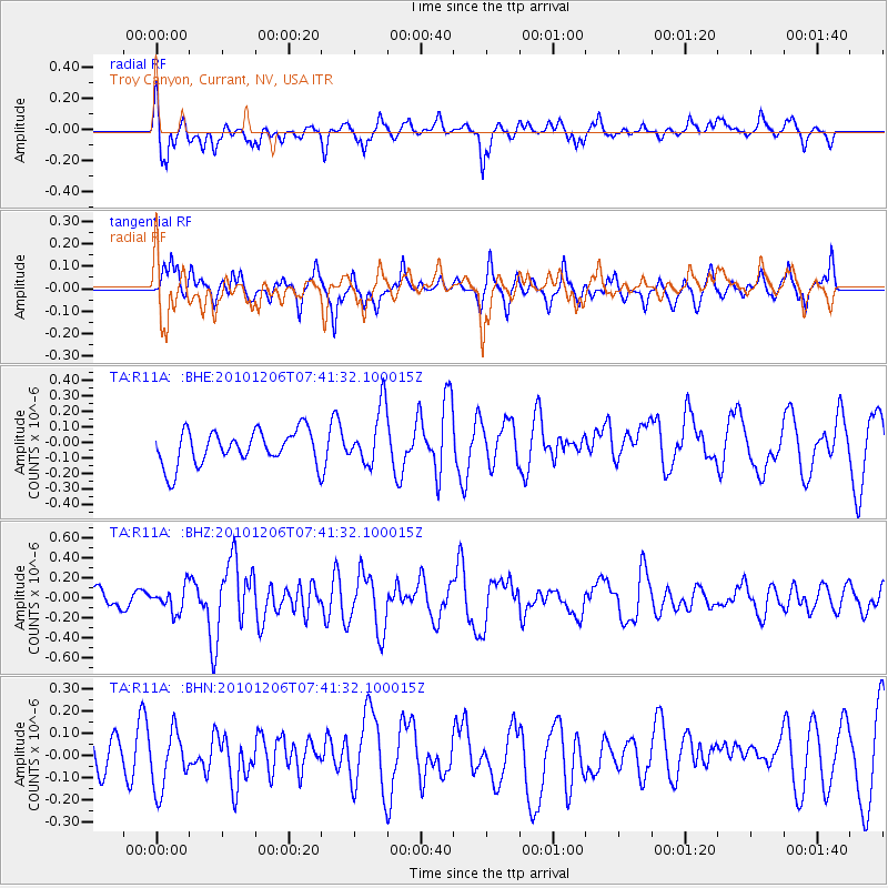
R11A Troy Canyon, Currant, NV, USA - Earthquake Result Viewer
*The percent match for this event was below the threshold and hence no stack was calculated.
| Earthquake location: |
Near East Coast Of Honshu, Japan |
| Earthquake latitude/longitude: |
40.9/143.0 |
| Earthquake time(UTC): |
2010/12/06 (340) 07:30:32 GMT |
| Earthquake Depth: |
22 km |
| Earthquake Magnitude: |
5.6 MB, 5.4 MS, 5.7 MW, 5.7 MW |
| Earthquake Catalog/Contributor: |
WHDF/NEIC |
|
| Network: |
TA USArray Transportable Network (new EarthScope stations) |
| Station: |
R11A Troy Canyon, Currant, NV, USA |
| Lat/Lon: |
38.35 N/115.59 W |
| Elevation: |
1756 m |
|
| Distance: |
73.5 deg |
| Az: |
53.505 deg |
| Baz: |
309.197 deg |
| Ray Param: |
$rayparam |
*The percent match for this event was below the threshold and hence was not used in the summary stack. |
|
| Radial Match: |
62.96409 % |
| Radial Bump: |
400 |
| Transverse Match: |
50.884438 % |
| Transverse Bump: |
377 |
| SOD ConfigId: |
343951 |
| Insert Time: |
2011-05-24 05:50:30.810 +0000 |
| GWidth: |
2.5 |
| Max Bumps: |
400 |
| Tol: |
0.001 |
|
Signal To Noise
| Channel | StoN | STA | LTA |
| TA:R11A: :BHZ:20101206T07:41:32.100015Z | 1.1268089 | 1.2200037E-7 | 1.0827069E-7 |
| TA:R11A: :BHN:20101206T07:41:32.100015Z | 1.1681694 | 1.340117E-7 | 1.147194E-7 |
| TA:R11A: :BHE:20101206T07:41:32.100015Z | 1.6796287 | 1.8612806E-7 | 1.1081501E-7 |
| Arrivals |
| Ps | |
| PpPs | |
| PsPs/PpSs | |


