You are here: Home > Network List > TA - USArray Transportable Network (new EarthScope stations) Stations List
> Station H28A Mission Ridge, SD, USA > Earthquake Result Viewer
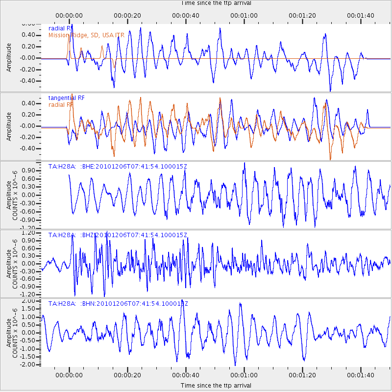
H28A Mission Ridge, SD, USA - Earthquake Result Viewer
*The percent match for this event was below the threshold and hence no stack was calculated.
| Earthquake location: |
Near East Coast Of Honshu, Japan |
| Earthquake latitude/longitude: |
40.9/143.0 |
| Earthquake time(UTC): |
2010/12/06 (340) 07:30:32 GMT |
| Earthquake Depth: |
22 km |
| Earthquake Magnitude: |
5.6 MB, 5.4 MS, 5.7 MW, 5.7 MW |
| Earthquake Catalog/Contributor: |
WHDF/NEIC |
|
| Network: |
TA USArray Transportable Network (new EarthScope stations) |
| Station: |
H28A Mission Ridge, SD, USA |
| Lat/Lon: |
44.68 N/101.02 W |
| Elevation: |
642 m |
|
| Distance: |
77.3 deg |
| Az: |
41.092 deg |
| Baz: |
315.711 deg |
| Ray Param: |
$rayparam |
*The percent match for this event was below the threshold and hence was not used in the summary stack. |
|
| Radial Match: |
67.689545 % |
| Radial Bump: |
326 |
| Transverse Match: |
51.805946 % |
| Transverse Bump: |
374 |
| SOD ConfigId: |
343951 |
| Insert Time: |
2011-05-24 05:55:47.246 +0000 |
| GWidth: |
2.5 |
| Max Bumps: |
400 |
| Tol: |
0.001 |
|
Signal To Noise
| Channel | StoN | STA | LTA |
| TA:H28A: :BHZ:20101206T07:41:54.100015Z | 3.0335562 | 5.157479E-7 | 1.7001427E-7 |
| TA:H28A: :BHN:20101206T07:41:54.100015Z | 0.37830058 | 2.4354287E-7 | 6.437814E-7 |
| TA:H28A: :BHE:20101206T07:41:54.100015Z | 1.4359245 | 5.3628474E-7 | 3.7347698E-7 |
| Arrivals |
| Ps | |
| PpPs | |
| PsPs/PpSs | |


