You are here: Home > Network List > TA - USArray Transportable Network (new EarthScope stations) Stations List
> Station N35A Tabor, IA, USA > Earthquake Result Viewer
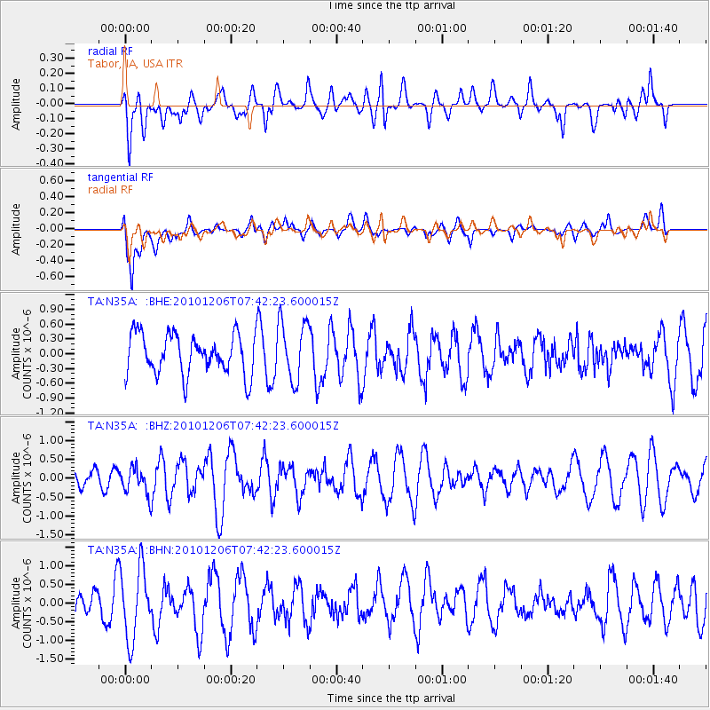
N35A Tabor, IA, USA - Earthquake Result Viewer
*The percent match for this event was below the threshold and hence no stack was calculated.
| Earthquake location: |
Near East Coast Of Honshu, Japan |
| Earthquake latitude/longitude: |
40.9/143.0 |
| Earthquake time(UTC): |
2010/12/06 (340) 07:30:32 GMT |
| Earthquake Depth: |
22 km |
| Earthquake Magnitude: |
5.6 MB, 5.4 MS, 5.7 MW, 5.7 MW |
| Earthquake Catalog/Contributor: |
WHDF/NEIC |
|
| Network: |
TA USArray Transportable Network (new EarthScope stations) |
| Station: |
N35A Tabor, IA, USA |
| Lat/Lon: |
40.86 N/95.64 W |
| Elevation: |
353 m |
|
| Distance: |
82.8 deg |
| Az: |
40.74 deg |
| Baz: |
319.292 deg |
| Ray Param: |
$rayparam |
*The percent match for this event was below the threshold and hence was not used in the summary stack. |
|
| Radial Match: |
47.32188 % |
| Radial Bump: |
400 |
| Transverse Match: |
73.57439 % |
| Transverse Bump: |
400 |
| SOD ConfigId: |
343951 |
| Insert Time: |
2011-05-24 06:06:46.783 +0000 |
| GWidth: |
2.5 |
| Max Bumps: |
400 |
| Tol: |
0.001 |
|
Signal To Noise
| Channel | StoN | STA | LTA |
| TA:N35A: :BHZ:20101206T07:42:23.600015Z | 0.980539 | 3.5653966E-7 | 3.6361595E-7 |
| TA:N35A: :BHN:20101206T07:42:23.600015Z | 2.568999 | 9.560371E-7 | 3.7214377E-7 |
| TA:N35A: :BHE:20101206T07:42:23.600015Z | 1.4998496 | 6.079512E-7 | 4.0534147E-7 |
| Arrivals |
| Ps | |
| PpPs | |
| PsPs/PpSs | |


