FRD AZ.FRD - Earthquake Result Viewer
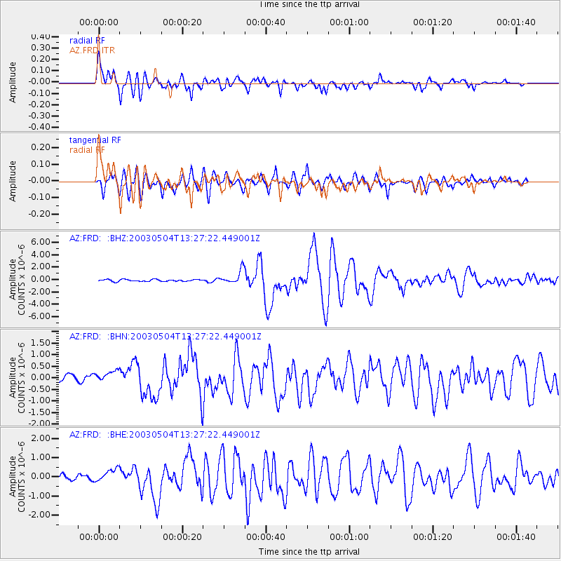
Earthquake location: Kermadec Islands, New Zealand
Earthquake latitude/longitude: -30.5/-178.2
Earthquake time(UTC): 2003/05/04 (124) 13:15:18 GMT
Earthquake Depth: 62 km
Earthquake Magnitude: 6.0 MB, 6.5 MS, 6.7 MW, 6.7 MW
Earthquake Catalog/Contributor: WHDF/NEIC
Network: AZ ANZA Regional Network
Station: FRD AZ.FRD
Lat/Lon: 33.49 N/116.60 W
Elevation: 1164 m
Distance: 86.3 deg
Az: 47.462 deg
Baz: 229.536 deg
Ray Param: 0.044054106
Estimated Moho Depth: 15.25 km
Estimated Crust Vp/Vs: 2.09
Assumed Crust Vp: 6.264 km/s
Estimated Crust Vs: 3.001 km/s
Estimated Crust Poisson's Ratio: 0.35
Radial Match: 91.732506 %
Radial Bump: 400
Transverse Match: 85.84118 %
Transverse Bump: 400
SOD ConfigId: 32974
Insert Time: 2010-02-26 19:11:44.832 +0000
GWidth: 2.5
Max Bumps: 400
Tol: 0.001

Signal To Noise

ChannelStoNSTALTA
AZ:FRD: :BHN:20030504T13:27:22.449001Z1.56566183.670745E-72.3445325E-7
AZ:FRD: :BHE:20030504T13:27:22.449001Z2.32228353.5155009E-71.513812E-7
AZ:FRD: :BHZ:20030504T13:27:22.449001Z7.4214841.1480624E-61.5469446E-7
Arrivals
Ps2.7 SECOND
PpPs7.4 SECOND
PsPs/PpSs10 SECOND