You are here: Home > Network List > CI - Caltech Regional Seismic Network Stations List
> Station FUR Furnace Creek, CA, USA > Earthquake Result Viewer
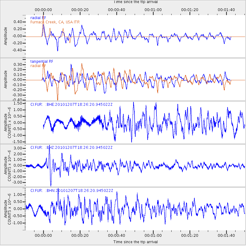
FUR Furnace Creek, CA, USA - Earthquake Result Viewer
*The percent match for this event was below the threshold and hence no stack was calculated.
| Earthquake location: |
Komandorskiye Ostrova Region |
| Earthquake latitude/longitude: |
54.4/169.1 |
| Earthquake time(UTC): |
2010/12/07 (341) 18:17:39 GMT |
| Earthquake Depth: |
10 km |
| Earthquake Magnitude: |
6.1 MB, 5.5 MS, 5.8 MW, 5.8 MW |
| Earthquake Catalog/Contributor: |
WHDF/NEIC |
|
| Network: |
CI Caltech Regional Seismic Network |
| Station: |
FUR Furnace Creek, CA, USA |
| Lat/Lon: |
36.47 N/116.86 W |
| Elevation: |
-37.0 m |
|
| Distance: |
52.4 deg |
| Az: |
77.883 deg |
| Baz: |
314.776 deg |
| Ray Param: |
$rayparam |
*The percent match for this event was below the threshold and hence was not used in the summary stack. |
|
| Radial Match: |
69.80524 % |
| Radial Bump: |
400 |
| Transverse Match: |
56.584763 % |
| Transverse Bump: |
400 |
| SOD ConfigId: |
343951 |
| Insert Time: |
2011-05-24 07:18:50.941 +0000 |
| GWidth: |
2.5 |
| Max Bumps: |
400 |
| Tol: |
0.001 |
|
Signal To Noise
| Channel | StoN | STA | LTA |
| CI:FUR: :BHZ:20101207T18:26:20.945022Z | 9.066621 | 1.4922682E-6 | 1.6458924E-7 |
| CI:FUR: :BHN:20101207T18:26:20.945022Z | 2.2258928 | 3.93356E-7 | 1.767183E-7 |
| CI:FUR: :BHE:20101207T18:26:20.945022Z | 1.2784922 | 3.3243947E-7 | 2.6002462E-7 |
| Arrivals |
| Ps | |
| PpPs | |
| PsPs/PpSs | |


