You are here: Home > Network List > TA - USArray Transportable Network (new EarthScope stations) Stations List
> Station 530A J-C Ranch, Comstock, TX, USA > Earthquake Result Viewer
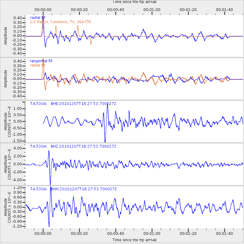
530A J-C Ranch, Comstock, TX, USA - Earthquake Result Viewer
| Earthquake location: |
Komandorskiye Ostrova Region |
| Earthquake latitude/longitude: |
54.4/169.1 |
| Earthquake time(UTC): |
2010/12/07 (341) 18:17:39 GMT |
| Earthquake Depth: |
10 km |
| Earthquake Magnitude: |
6.1 MB, 5.5 MS, 5.8 MW, 5.8 MW |
| Earthquake Catalog/Contributor: |
WHDF/NEIC |
|
| Network: |
TA USArray Transportable Network (new EarthScope stations) |
| Station: |
530A J-C Ranch, Comstock, TX, USA |
| Lat/Lon: |
30.15 N/101.34 W |
| Elevation: |
636 m |
|
| Distance: |
65.8 deg |
| Az: |
71.675 deg |
| Baz: |
320.103 deg |
| Ray Param: |
0.05800615 |
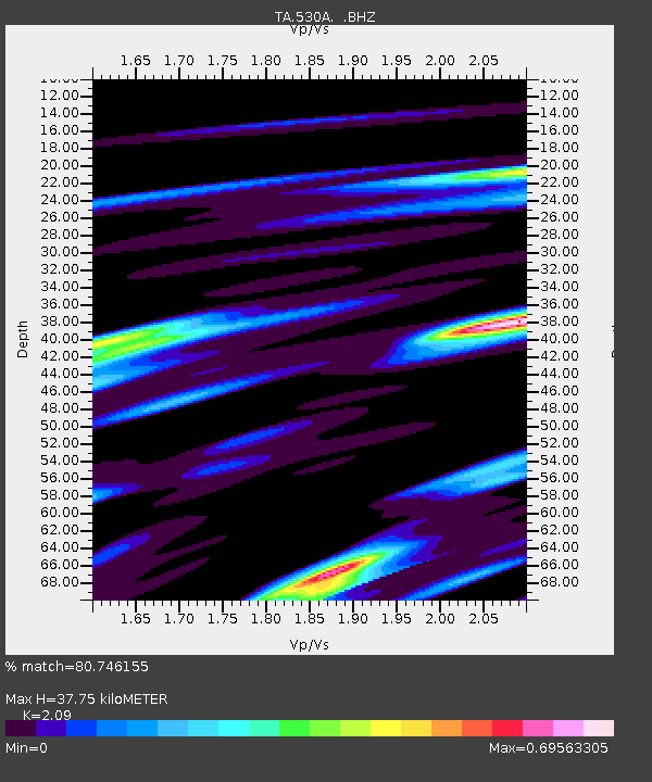
| Estimated Moho Depth: |
37.75 km |
| Estimated Crust Vp/Vs: |
2.09 |
| Assumed Crust Vp: |
6.38 km/s |
| Estimated Crust Vs: |
3.053 km/s |
| Estimated Crust Poisson's Ratio: |
0.35 |
|
| Radial Match: |
80.746155 % |
| Radial Bump: |
374 |
| Transverse Match: |
54.71482 % |
| Transverse Bump: |
400 |
| SOD ConfigId: |
343951 |
| Insert Time: |
2011-05-24 08:21:55.509 +0000 |
| GWidth: |
2.5 |
| Max Bumps: |
400 |
| Tol: |
0.001 |
|
Signal To Noise
| Channel | StoN | STA | LTA |
| TA:530A: :BHZ:20101207T18:27:53.700027Z | 9.914708 | 1.8192056E-6 | 1.8348555E-7 |
| TA:530A: :BHN:20101207T18:27:53.700027Z | 4.2588935 | 5.2784253E-7 | 1.2393889E-7 |
| TA:530A: :BHE:20101207T18:27:53.700027Z | 2.7384293 | 5.5912244E-7 | 2.0417632E-7 |
| Arrivals |
| Ps | 6.7 SECOND |
| PpPs | 18 SECOND |
| PsPs/PpSs | 24 SECOND |


