You are here: Home > Network List > IU - Global Seismograph Network (GSN - IRIS/USGS) Stations List
> Station PMG Port Moresby, New Guinea > Earthquake Result Viewer
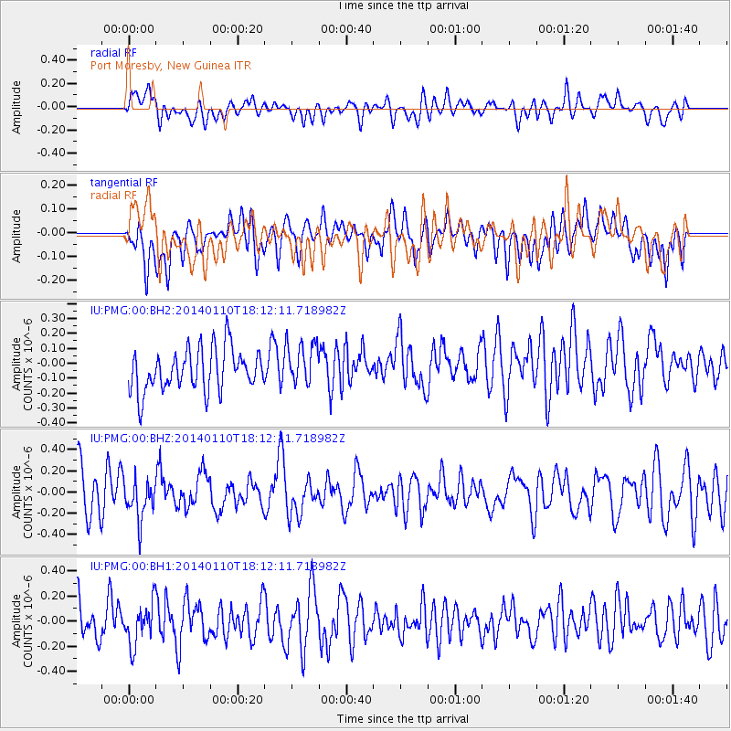
PMG Port Moresby, New Guinea - Earthquake Result Viewer
*The percent match for this event was below the threshold and hence no stack was calculated.
| Earthquake location: |
Kuril Islands |
| Earthquake latitude/longitude: |
48.2/154.1 |
| Earthquake time(UTC): |
2014/01/10 (010) 18:03:00 GMT |
| Earthquake Depth: |
82 km |
| Earthquake Magnitude: |
5.1 MW |
| Earthquake Catalog/Contributor: |
ISC/ISC |
|
| Network: |
IU Global Seismograph Network (GSN - IRIS/USGS) |
| Station: |
PMG Port Moresby, New Guinea |
| Lat/Lon: |
9.40 S/147.16 E |
| Elevation: |
90 m |
|
| Distance: |
57.7 deg |
| Az: |
188.117 deg |
| Baz: |
5.495 deg |
| Ray Param: |
$rayparam |
*The percent match for this event was below the threshold and hence was not used in the summary stack. |
|
| Radial Match: |
44.367683 % |
| Radial Bump: |
400 |
| Transverse Match: |
45.732018 % |
| Transverse Bump: |
400 |
| SOD ConfigId: |
3390531 |
| Insert Time: |
2019-04-09 23:17:40.874 +0000 |
| GWidth: |
2.5 |
| Max Bumps: |
400 |
| Tol: |
0.001 |
|
Signal To Noise
| Channel | StoN | STA | LTA |
| IU:PMG:00:BHZ:20140110T18:12:11.718982Z | 0.846356 | 1.8631572E-7 | 2.2013872E-7 |
| IU:PMG:00:BH1:20140110T18:12:11.718982Z | 1.1134477 | 1.6531912E-7 | 1.4847498E-7 |
| IU:PMG:00:BH2:20140110T18:12:11.718982Z | 1.0122437 | 1.4259587E-7 | 1.4087108E-7 |
| Arrivals |
| Ps | |
| PpPs | |
| PsPs/PpSs | |


