You are here: Home > Network List > KN - Kyrgyz Seismic Telemetry Network Stations List
> Station ULHL - > Earthquake Result Viewer
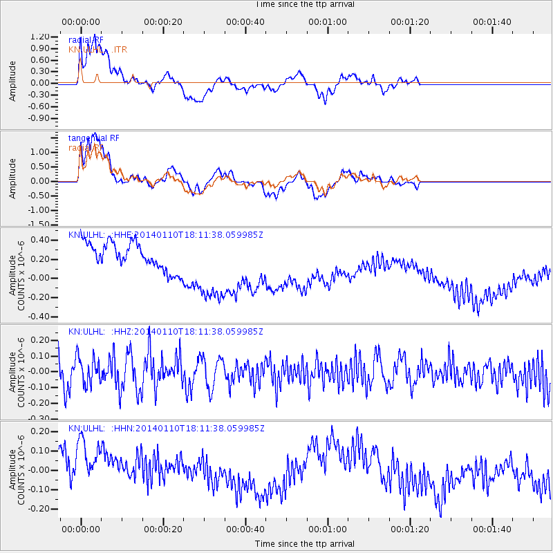
ULHL - - Earthquake Result Viewer
*The percent match for this event was below the threshold and hence no stack was calculated.
| Earthquake location: |
Kuril Islands |
| Earthquake latitude/longitude: |
48.2/154.1 |
| Earthquake time(UTC): |
2014/01/10 (010) 18:03:00 GMT |
| Earthquake Depth: |
82 km |
| Earthquake Magnitude: |
5.1 MW |
| Earthquake Catalog/Contributor: |
ISC/ISC |
|
| Network: |
KN Kyrgyz Seismic Telemetry Network |
| Station: |
ULHL - |
| Lat/Lon: |
42.25 N/76.24 E |
| Elevation: |
2040 m |
|
| Distance: |
53.0 deg |
| Az: |
294.593 deg |
| Baz: |
55.035 deg |
| Ray Param: |
$rayparam |
*The percent match for this event was below the threshold and hence was not used in the summary stack. |
|
| Radial Match: |
61.047306 % |
| Radial Bump: |
400 |
| Transverse Match: |
50.693317 % |
| Transverse Bump: |
400 |
| SOD ConfigId: |
3390531 |
| Insert Time: |
2019-04-09 23:17:48.616 +0000 |
| GWidth: |
2.5 |
| Max Bumps: |
400 |
| Tol: |
0.001 |
|
Signal To Noise
| Channel | StoN | STA | LTA |
| KN:ULHL: :HHZ:20140110T18:11:38.059985Z | 1.2490015 | 8.8400846E-8 | 7.077721E-8 |
| KN:ULHL: :HHN:20140110T18:11:38.059985Z | 2.1144025 | 2.5600443E-7 | 1.2107648E-7 |
| KN:ULHL: :HHE:20140110T18:11:38.059985Z | 2.8773174 | 4.027198E-7 | 1.3996363E-7 |
| Arrivals |
| Ps | |
| PpPs | |
| PsPs/PpSs | |


