You are here: Home > Network List > TA - USArray Transportable Network (new EarthScope stations) Stations List
> Station 340A Bronson, TX, USA > Earthquake Result Viewer
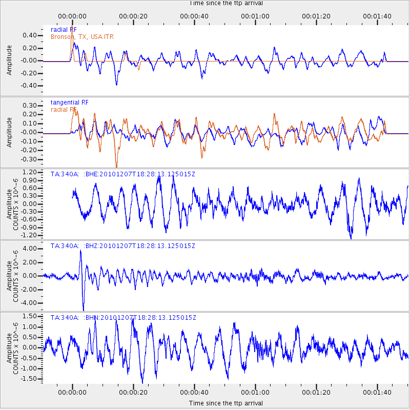
340A Bronson, TX, USA - Earthquake Result Viewer
*The percent match for this event was below the threshold and hence no stack was calculated.
| Earthquake location: |
Komandorskiye Ostrova Region |
| Earthquake latitude/longitude: |
54.4/169.1 |
| Earthquake time(UTC): |
2010/12/07 (341) 18:17:39 GMT |
| Earthquake Depth: |
10 km |
| Earthquake Magnitude: |
6.1 MB, 5.5 MS, 5.8 MW, 5.8 MW |
| Earthquake Catalog/Contributor: |
WHDF/NEIC |
|
| Network: |
TA USArray Transportable Network (new EarthScope stations) |
| Station: |
340A Bronson, TX, USA |
| Lat/Lon: |
31.42 N/93.89 W |
| Elevation: |
57 m |
|
| Distance: |
68.9 deg |
| Az: |
65.431 deg |
| Baz: |
321.495 deg |
| Ray Param: |
$rayparam |
*The percent match for this event was below the threshold and hence was not used in the summary stack. |
|
| Radial Match: |
42.737907 % |
| Radial Bump: |
365 |
| Transverse Match: |
32.53281 % |
| Transverse Bump: |
395 |
| SOD ConfigId: |
343951 |
| Insert Time: |
2011-05-24 09:49:41.679 +0000 |
| GWidth: |
2.5 |
| Max Bumps: |
400 |
| Tol: |
0.001 |
|
Signal To Noise
| Channel | StoN | STA | LTA |
| TA:340A: :BHZ:20101207T18:28:13.125015Z | 8.957878 | 1.843033E-6 | 2.0574437E-7 |
| TA:340A: :BHN:20101207T18:28:13.125015Z | 0.84263486 | 4.5634954E-7 | 5.4157454E-7 |
| TA:340A: :BHE:20101207T18:28:13.125015Z | 1.5281343 | 6.180663E-7 | 4.0445806E-7 |
| Arrivals |
| Ps | |
| PpPs | |
| PsPs/PpSs | |


