You are here: Home > Network List > TA - USArray Transportable Network (new EarthScope stations) Stations List
> Station O03E Paynes Creek, CA, USA > Earthquake Result Viewer
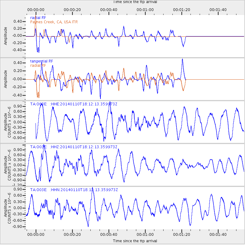
O03E Paynes Creek, CA, USA - Earthquake Result Viewer
*The percent match for this event was below the threshold and hence no stack was calculated.
| Earthquake location: |
Kuril Islands |
| Earthquake latitude/longitude: |
48.2/154.1 |
| Earthquake time(UTC): |
2014/01/10 (010) 18:03:00 GMT |
| Earthquake Depth: |
82 km |
| Earthquake Magnitude: |
5.1 MW |
| Earthquake Catalog/Contributor: |
ISC/ISC |
|
| Network: |
TA USArray Transportable Network (new EarthScope stations) |
| Station: |
O03E Paynes Creek, CA, USA |
| Lat/Lon: |
40.29 N/121.80 W |
| Elevation: |
967 m |
|
| Distance: |
57.9 deg |
| Az: |
63.907 deg |
| Baz: |
308.21 deg |
| Ray Param: |
$rayparam |
*The percent match for this event was below the threshold and hence was not used in the summary stack. |
|
| Radial Match: |
75.62142 % |
| Radial Bump: |
400 |
| Transverse Match: |
87.0717 % |
| Transverse Bump: |
400 |
| SOD ConfigId: |
3390531 |
| Insert Time: |
2019-04-09 23:20:18.449 +0000 |
| GWidth: |
2.5 |
| Max Bumps: |
400 |
| Tol: |
0.001 |
|
Signal To Noise
| Channel | StoN | STA | LTA |
| TA:O03E: :HHZ:20140110T18:12:13.359973Z | 2.1301937 | 7.03972E-7 | 3.3047323E-7 |
| TA:O03E: :HHN:20140110T18:12:13.359973Z | 0.62369806 | 2.3676196E-7 | 3.7960993E-7 |
| TA:O03E: :HHE:20140110T18:12:13.359973Z | 0.80646425 | 4.5659013E-7 | 5.661629E-7 |
| Arrivals |
| Ps | |
| PpPs | |
| PsPs/PpSs | |


