You are here: Home > Network List > TA - USArray Transportable Network (new EarthScope stations) Stations List
> Station F33A 5 Mile Ranch, Herman, MN, USA > Earthquake Result Viewer
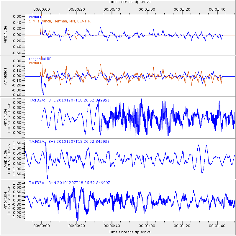
F33A 5 Mile Ranch, Herman, MN, USA - Earthquake Result Viewer
*The percent match for this event was below the threshold and hence no stack was calculated.
| Earthquake location: |
Komandorskiye Ostrova Region |
| Earthquake latitude/longitude: |
54.4/169.1 |
| Earthquake time(UTC): |
2010/12/07 (341) 18:17:39 GMT |
| Earthquake Depth: |
10 km |
| Earthquake Magnitude: |
6.1 MB, 5.5 MS, 5.8 MW, 5.8 MW |
| Earthquake Catalog/Contributor: |
WHDF/NEIC |
|
| Network: |
TA USArray Transportable Network (new EarthScope stations) |
| Station: |
F33A 5 Mile Ranch, Herman, MN, USA |
| Lat/Lon: |
45.84 N/96.29 W |
| Elevation: |
313 m |
|
| Distance: |
56.8 deg |
| Az: |
56.351 deg |
| Baz: |
315.819 deg |
| Ray Param: |
$rayparam |
*The percent match for this event was below the threshold and hence was not used in the summary stack. |
|
| Radial Match: |
69.18919 % |
| Radial Bump: |
375 |
| Transverse Match: |
64.76382 % |
| Transverse Bump: |
379 |
| SOD ConfigId: |
343951 |
| Insert Time: |
2011-05-24 10:33:01.950 +0000 |
| GWidth: |
2.5 |
| Max Bumps: |
400 |
| Tol: |
0.001 |
|
Signal To Noise
| Channel | StoN | STA | LTA |
| TA:F33A: :BHZ:20101207T18:26:52.84999Z | 2.2549791 | 8.5328975E-7 | 3.7840252E-7 |
| TA:F33A: :BHN:20101207T18:26:52.84999Z | 1.0408378 | 2.1930792E-7 | 2.1070328E-7 |
| TA:F33A: :BHE:20101207T18:26:52.84999Z | 1.6595398 | 5.89398E-7 | 3.5515748E-7 |
| Arrivals |
| Ps | |
| PpPs | |
| PsPs/PpSs | |


