You are here: Home > Network List > TA - USArray Transportable Network (new EarthScope stations) Stations List
> Station H36A Jessenland, Henderson, MN, USA > Earthquake Result Viewer
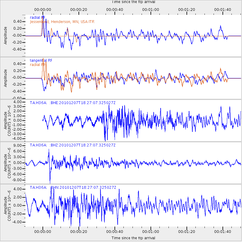
H36A Jessenland, Henderson, MN, USA - Earthquake Result Viewer
*The percent match for this event was below the threshold and hence no stack was calculated.
| Earthquake location: |
Komandorskiye Ostrova Region |
| Earthquake latitude/longitude: |
54.4/169.1 |
| Earthquake time(UTC): |
2010/12/07 (341) 18:17:39 GMT |
| Earthquake Depth: |
10 km |
| Earthquake Magnitude: |
6.1 MB, 5.5 MS, 5.8 MW, 5.8 MW |
| Earthquake Catalog/Contributor: |
WHDF/NEIC |
|
| Network: |
TA USArray Transportable Network (new EarthScope stations) |
| Station: |
H36A Jessenland, Henderson, MN, USA |
| Lat/Lon: |
44.58 N/93.93 W |
| Elevation: |
311 m |
|
| Distance: |
58.9 deg |
| Az: |
55.943 deg |
| Baz: |
317.275 deg |
| Ray Param: |
$rayparam |
*The percent match for this event was below the threshold and hence was not used in the summary stack. |
|
| Radial Match: |
69.69292 % |
| Radial Bump: |
400 |
| Transverse Match: |
63.98902 % |
| Transverse Bump: |
400 |
| SOD ConfigId: |
343951 |
| Insert Time: |
2011-05-24 10:46:25.487 +0000 |
| GWidth: |
2.5 |
| Max Bumps: |
400 |
| Tol: |
0.001 |
|
Signal To Noise
| Channel | StoN | STA | LTA |
| TA:H36A: :BHZ:20101207T18:27:07.325027Z | 4.0824194 | 2.9360249E-6 | 7.191874E-7 |
| TA:H36A: :BHN:20101207T18:27:07.325027Z | 1.3969362 | 1.4877398E-6 | 1.065002E-6 |
| TA:H36A: :BHE:20101207T18:27:07.325027Z | 1.6916262 | 1.2886799E-6 | 7.617994E-7 |
| Arrivals |
| Ps | |
| PpPs | |
| PsPs/PpSs | |


