You are here: Home > Network List > US - United States National Seismic Network Stations List
> Station WUAZ Wupatki, Arizona, USA > Earthquake Result Viewer
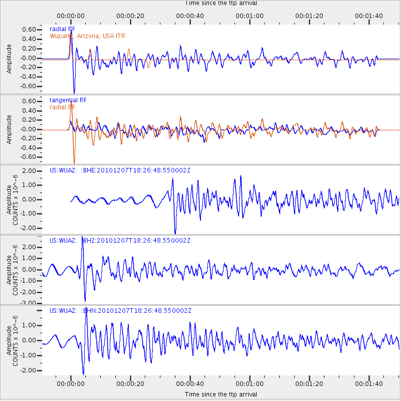
WUAZ Wupatki, Arizona, USA - Earthquake Result Viewer
*The percent match for this event was below the threshold and hence no stack was calculated.
| Earthquake location: |
Komandorskiye Ostrova Region |
| Earthquake latitude/longitude: |
54.4/169.1 |
| Earthquake time(UTC): |
2010/12/07 (341) 18:17:39 GMT |
| Earthquake Depth: |
10 km |
| Earthquake Magnitude: |
6.1 MB, 5.5 MS, 5.8 MW, 5.8 MW |
| Earthquake Catalog/Contributor: |
WHDF/NEIC |
|
| Network: |
US United States National Seismic Network |
| Station: |
WUAZ Wupatki, Arizona, USA |
| Lat/Lon: |
35.52 N/111.37 W |
| Elevation: |
1592 m |
|
| Distance: |
56.2 deg |
| Az: |
74.794 deg |
| Baz: |
316.187 deg |
| Ray Param: |
$rayparam |
*The percent match for this event was below the threshold and hence was not used in the summary stack. |
|
| Radial Match: |
76.43993 % |
| Radial Bump: |
400 |
| Transverse Match: |
66.024445 % |
| Transverse Bump: |
400 |
| SOD ConfigId: |
343951 |
| Insert Time: |
2011-05-24 11:12:12.947 +0000 |
| GWidth: |
2.5 |
| Max Bumps: |
400 |
| Tol: |
0.001 |
|
Signal To Noise
| Channel | StoN | STA | LTA |
| US:WUAZ: :BHZ:20101207T18:26:48.550002Z | 4.761789 | 1.0845313E-6 | 2.2775713E-7 |
| US:WUAZ: :BHN:20101207T18:26:48.550002Z | 5.4254107 | 7.394035E-7 | 1.3628527E-7 |
| US:WUAZ: :BHE:20101207T18:26:48.550002Z | 4.308343 | 5.9870524E-7 | 1.3896415E-7 |
| Arrivals |
| Ps | |
| PpPs | |
| PsPs/PpSs | |


