You are here: Home > Network List > US - United States National Seismic Network Stations List
> Station DGMT Dagmar, Montana, USA > Earthquake Result Viewer
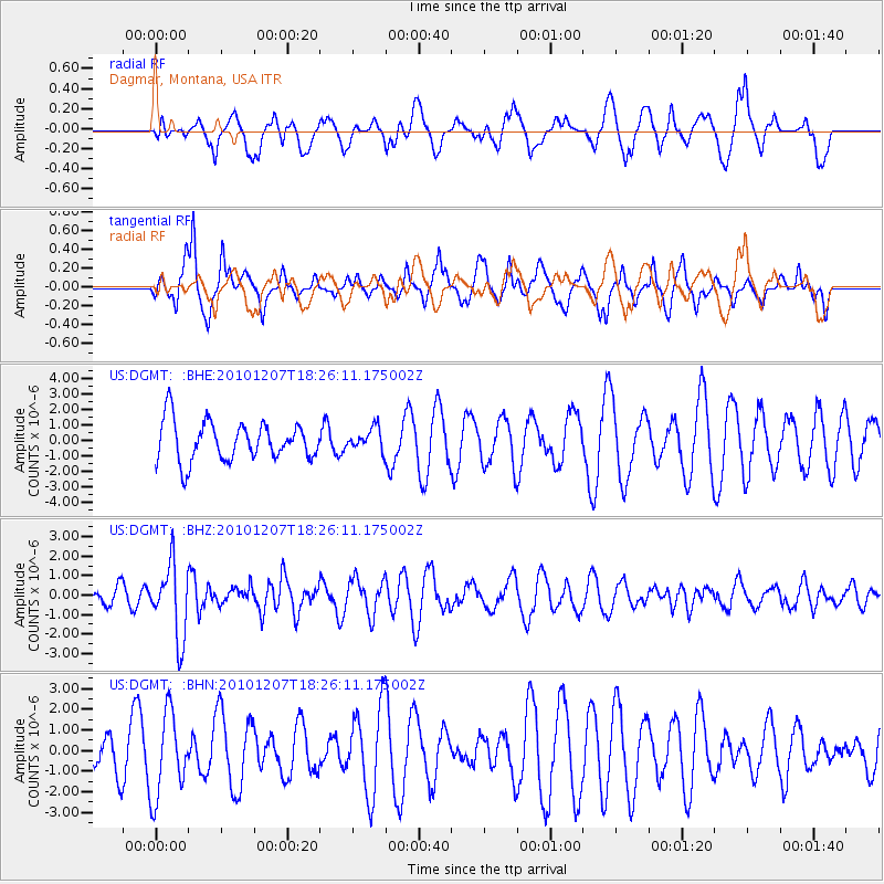
DGMT Dagmar, Montana, USA - Earthquake Result Viewer
*The percent match for this event was below the threshold and hence no stack was calculated.
| Earthquake location: |
Komandorskiye Ostrova Region |
| Earthquake latitude/longitude: |
54.4/169.1 |
| Earthquake time(UTC): |
2010/12/07 (341) 18:17:39 GMT |
| Earthquake Depth: |
10 km |
| Earthquake Magnitude: |
6.1 MB, 5.5 MS, 5.8 MW, 5.8 MW |
| Earthquake Catalog/Contributor: |
WHDF/NEIC |
|
| Network: |
US United States National Seismic Network |
| Station: |
DGMT Dagmar, Montana, USA |
| Lat/Lon: |
48.47 N/104.20 W |
| Elevation: |
0.0 m |
|
| Distance: |
51.1 deg |
| Az: |
58.594 deg |
| Baz: |
311.359 deg |
| Ray Param: |
$rayparam |
*The percent match for this event was below the threshold and hence was not used in the summary stack. |
|
| Radial Match: |
30.832447 % |
| Radial Bump: |
400 |
| Transverse Match: |
31.346949 % |
| Transverse Bump: |
311 |
| SOD ConfigId: |
343951 |
| Insert Time: |
2011-05-24 11:18:37.394 +0000 |
| GWidth: |
2.5 |
| Max Bumps: |
400 |
| Tol: |
0.001 |
|
Signal To Noise
| Channel | StoN | STA | LTA |
| US:DGMT: :BHZ:20101207T18:26:11.175002Z | 4.4898767 | 1.8702699E-6 | 4.1655258E-7 |
| US:DGMT: :BHN:20101207T18:26:11.175002Z | 1.2365018 | 2.0169266E-6 | 1.6311553E-6 |
| US:DGMT: :BHE:20101207T18:26:11.175002Z | 0.56320137 | 7.104172E-7 | 1.2613912E-6 |
| Arrivals |
| Ps | |
| PpPs | |
| PsPs/PpSs | |


