You are here: Home > Network List > G - GEOSCOPE Stations List
> Station RER Riviere de l'Est, La Reunion (Indian Ocean) > Earthquake Result Viewer
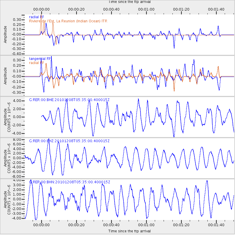
RER Riviere de l'Est, La Reunion (Indian Ocean) - Earthquake Result Viewer
*The percent match for this event was below the threshold and hence no stack was calculated.
| Earthquake location: |
South Sandwich Islands Region |
| Earthquake latitude/longitude: |
-56.4/-25.7 |
| Earthquake time(UTC): |
2010/12/08 (342) 05:24:35 GMT |
| Earthquake Depth: |
29 km |
| Earthquake Magnitude: |
6.1 MB, 6.2 MS, 6.3 MW, 6.3 MW |
| Earthquake Catalog/Contributor: |
WHDF/NEIC |
|
| Network: |
G GEOSCOPE |
| Station: |
RER Riviere de l'Est, La Reunion (Indian Ocean) |
| Lat/Lon: |
21.16 S/55.75 E |
| Elevation: |
834 m |
|
| Distance: |
68.0 deg |
| Az: |
95.235 deg |
| Baz: |
216.368 deg |
| Ray Param: |
$rayparam |
*The percent match for this event was below the threshold and hence was not used in the summary stack. |
|
| Radial Match: |
53.857334 % |
| Radial Bump: |
400 |
| Transverse Match: |
70.06352 % |
| Transverse Bump: |
400 |
| SOD ConfigId: |
343951 |
| Insert Time: |
2011-05-24 11:47:43.871 +0000 |
| GWidth: |
2.5 |
| Max Bumps: |
400 |
| Tol: |
0.001 |
|
Signal To Noise
| Channel | StoN | STA | LTA |
| G:RER:00:BHZ:20101208T05:35:00.400015Z | 2.9777613 | 4.600612E-6 | 1.5449903E-6 |
| G:RER:00:BHN:20101208T05:35:00.400015Z | 1.0488834 | 2.3410018E-6 | 2.2318989E-6 |
| G:RER:00:BHE:20101208T05:35:00.400015Z | 1.4487742 | 2.543198E-6 | 1.7554137E-6 |
| Arrivals |
| Ps | |
| PpPs | |
| PsPs/PpSs | |


