You are here: Home > Network List > G - GEOSCOPE Stations List
> Station FDF Fort de France, Martinique France > Earthquake Result Viewer
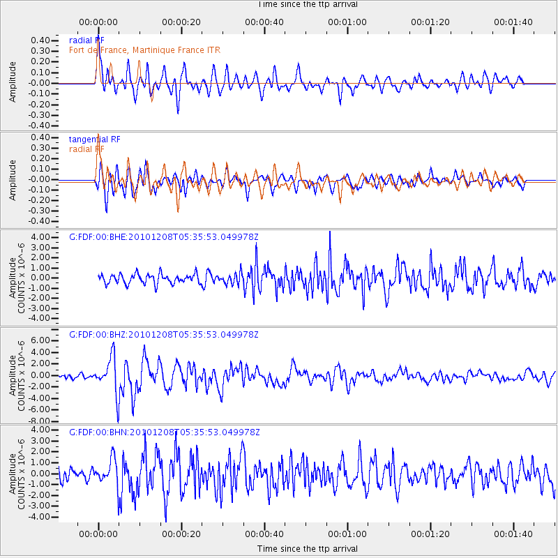
FDF Fort de France, Martinique France - Earthquake Result Viewer
*The percent match for this event was below the threshold and hence no stack was calculated.
| Earthquake location: |
South Sandwich Islands Region |
| Earthquake latitude/longitude: |
-56.4/-25.7 |
| Earthquake time(UTC): |
2010/12/08 (342) 05:24:35 GMT |
| Earthquake Depth: |
29 km |
| Earthquake Magnitude: |
6.1 MB, 6.2 MS, 6.3 MW, 6.3 MW |
| Earthquake Catalog/Contributor: |
WHDF/NEIC |
|
| Network: |
G GEOSCOPE |
| Station: |
FDF Fort de France, Martinique France |
| Lat/Lon: |
14.73 N/61.14 W |
| Elevation: |
467 m |
|
| Distance: |
76.8 deg |
| Az: |
324.852 deg |
| Baz: |
160.688 deg |
| Ray Param: |
$rayparam |
*The percent match for this event was below the threshold and hence was not used in the summary stack. |
|
| Radial Match: |
77.751724 % |
| Radial Bump: |
400 |
| Transverse Match: |
75.10242 % |
| Transverse Bump: |
400 |
| SOD ConfigId: |
343951 |
| Insert Time: |
2011-05-24 11:48:20.219 +0000 |
| GWidth: |
2.5 |
| Max Bumps: |
400 |
| Tol: |
0.001 |
|
Signal To Noise
| Channel | StoN | STA | LTA |
| G:FDF:00:BHZ:20101208T05:35:53.049978Z | 9.809793 | 3.2953762E-6 | 3.3592718E-7 |
| G:FDF:00:BHN:20101208T05:35:53.049978Z | 2.2301567 | 1.247457E-6 | 5.5935845E-7 |
| G:FDF:00:BHE:20101208T05:35:53.049978Z | 1.12403 | 5.22523E-7 | 4.6486574E-7 |
| Arrivals |
| Ps | |
| PpPs | |
| PsPs/PpSs | |


