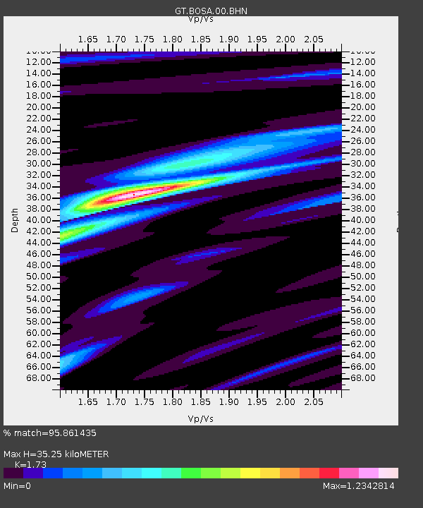
BOSA Boshof, South Africa - Earthquake Result Viewer
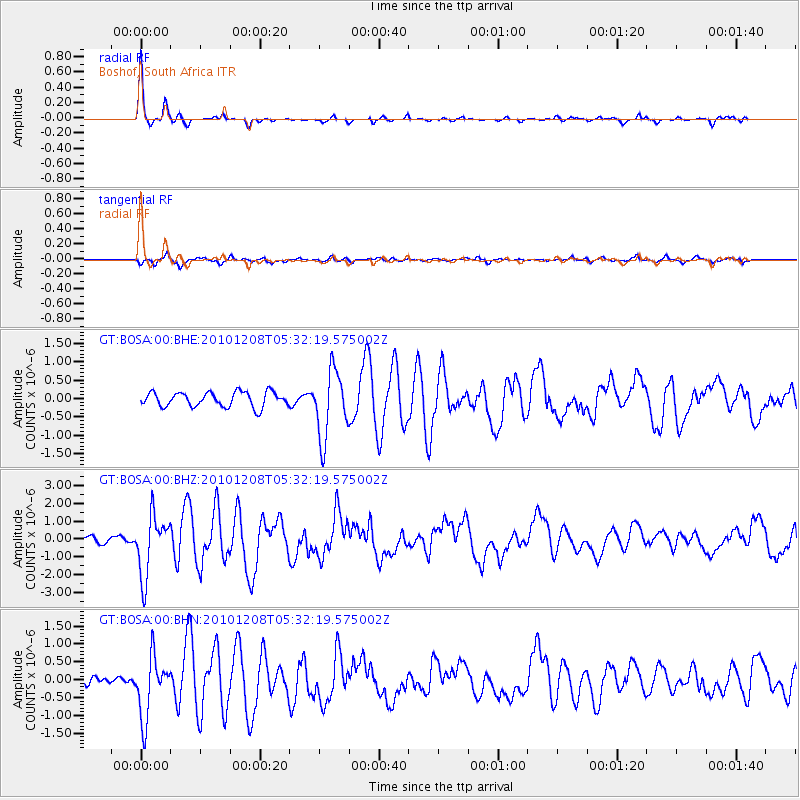
Earthquake location: South Sandwich Islands Region
Earthquake latitude/longitude: -56.4/-25.7
Earthquake time(UTC): 2010/12/08 (342) 05:24:35 GMT
Earthquake Depth: 29 km
Earthquake Magnitude: 6.1 MB, 6.2 MS, 6.3 MW, 6.3 MW
Earthquake Catalog/Contributor: WHDF/NEIC
Network: GT Global Telemetered Seismograph Network (USAF/USGS)
Station: BOSA Boshof, South Africa
Lat/Lon: 28.61 S/25.26 E
Elevation: 1280 m
Distance: 45.3 deg
Az: 74.055 deg
Baz: 217.433 deg
Ray Param: 0.071324356
Estimated Moho Depth: 35.25 km
Estimated Crust Vp/Vs: 1.73
Assumed Crust Vp: 6.459 km/s
Estimated Crust Vs: 3.734 km/s
Estimated Crust Poisson's Ratio: 0.25
Radial Match: 95.861435 %
Radial Bump: 209
Transverse Match: 70.85911 %
Transverse Bump: 400
SOD ConfigId: 343951
Insert Time: 2011-05-24 11:50:09.925 +0000
GWidth: 2.5
Max Bumps: 400
Tol: 0.001

Signal To Noise

ChannelStoNSTALTA
GT:BOSA:00:BHZ:20101208T05:32:19.575002Z8.996411.6942715E-61.8832752E-7
GT:BOSA:00:BHN:20101208T05:32:19.575002Z5.0250568.490327E-71.6895986E-7
GT:BOSA:00:BHE:20101208T05:32:19.575002Z4.59546859.186705E-71.999079E-7
Arrivals
Ps4.3 SECOND
PpPs14 SECOND
PsPs/PpSs18 SECOND